Professional GIS Mapping Services

AeroViews delivers comprehensive GIS mapping services combining advanced drone technology with professional geospatial analysis to help you make informed decisions about your properties, projects, and resources.

gis-mapping-services
  • High-Accuracy Spatial Data
  • GIS-Ready Deliverables
  • Fast Turnaround Times

Our Comprehensive GIS Mapping Services

AeroViews provides a complete suite of GIS mapping services designed to meet the diverse needs of
California’s development, infrastructure, and resource management sectors.

Cadastral Mapping for Land Registration

Cadastral Mapping for Land Registration

Our cadastral mapping services create detailed records of property boundaries, ownership parcels, and land rights essential for real estate development, municipal planning, and land registration. Organizations use our cadastral data to manage land parcels efficiently, ensuring accurate records for legal and administrative purposes.

topographical mapping

Topographical Mapping

Topographical mapping captures terrain elevation, contours, and natural features critical for engineering design, drainage planning, and construction site analysis. Our drone-based topographic surveys deliver centimeter-accurate elevation data across large sites. The geospatial data we collect provides the foundation for accurate volume calculations and site planning.

Parcel Mapping

Parcel Mapping

Parcel mapping services create the foundational geographic data layer for land administration and property management systems. Our parcel maps provide the spatial framework for property tax systems, land use regulation, and infrastructure planning across jurisdictions. Each land parcel is precisely georeferenced and attributed with relevant information.

Utility Mapping

Utility Mapping

Utility mapping documents the location, condition, and connectivity of underground and overhead infrastructure including water, sewer, electrical, telecommunications, and gas networks. The spatial information we provide enables utilities to optimize operations and resource allocation across various industries.

Geological Mapping

Geological Mapping

Geological mapping integrates surface terrain data with subsurface characteristics to support mining operations, geotechnical engineering, and natural resource exploration. As noted in industry research, geological mapping is crucial for natural resource exploration and environmental management.

Land Use Land Cover (LULC) Mapping

Land Use Land Cover (LULC) Mapping

Our land use planning map services identify and categorize areas as residential, commercial, industrial, agricultural, forest, wetland, or open space using sophisticated classification algorithms that analyze spatial data patterns. LULC maps help organizations identify patterns in development trends.

Zoning and Planning Maps

Zoning and Planning Maps

Our zoning classification map and commercial zoning map services visualize regulatory districts, permitted uses, and development standards. These maps use fill color schemes to distinguish different zoning designations clearly. Users can search for properties by zoning type and query attributes to find relevant information quickly.

Base Mapping for Geographic Information Systems

Base Mapping for Geographic Information Systems

Base mapping establishes the foundational geographic reference layer showing roads, buildings, water features, and key landmarks. As a basic map layer, these datasets enable users to add new layers for specific analysis purposes while maintaining accurate spatial registration across different data types.

Geo-Referencing

Geo-referencing converts legacy maps, engineering drawings, and historical documents into spatially accurate digital formats aligned with real-world coordinates. This ensures all spatial information maintains consistent accuracy regardless of original format or creation date.

Map Digitization and Data Conversion

Map Digitization and Data Conversion

Our map digitization services transform paper maps, scanned documents, and analog records into digital GIS data with full attribute information and topology. Organizations can save digitized data in one format for consistent access across different platforms and device types.

Indoor Mapping

Indoor Mapping

Our indoor gis map creation services document room layouts, wayfinding routes, asset locations, and space utilization to support facility management, emergency response planning, and visitor navigation systems. These maps enable organizations to share map data across teams and provide location-based services on any device.

GIS Mapping Projects We’ve Completed

We deploy specialized powerline inspection drones with advanced imaging technologies to capture precise data and high quality data for utility companies.

Parcel Boundary and Orchard Location Map

Parcel Boundary and Orchard Location Map

Detailed parcel boundary mapping for agricultural property in Santa Barbara County, integrating USDA NRCS data with property boundaries, orchard locations, wetlands inventory, and soil classifications. This project demonstrates our ability to work with existing datasets and create comprehensive multi-layer maps for land use planning.

2-Mile Context Radius Planning Map

2-Mile Context Radius Planning Map

Planning-level exhibit showing subject parcels, zoning districts, and separation distances within a 2-mile context radius. Created using existing City/County GIS data including parcels, streets, and zoning layers. This type of map is essential for land use applications, conditional use permits, and environmental review processes.

750-Foot Context Radius Detail Map

750-Foot Context Radius Detail Map

Close-up planning exhibit showing proposed site improvements, parcel boundaries, and R-1 zoning districts within a 750-foot radius. Demonstrates our expertise in creating detailed context maps that help planners and developers understand site relationships, setbacks, and regulatory constraints for development projects.

Turn Your GIS Data Into Actionable Maps

We provide high-accuracy GIS mapping and spatial data products to support planning, engineering, and development projects.

Industries We Serve with GIS Technology

Leading organizations in virtually every field use geographic information systems to support daily operations and guide long-term strategies.

urban planning flat icon

Urban Planning and Development

Municipal planners and developers rely on our land use planning maps, zoning classification maps, and parcel mapping to guide growth management. Planners can find data about existing conditions, overlay various data layers to analyze spatial relationships, and create dynamic maps that communicate planning proposals effectively.

utilities flat icon

Utilities and Infrastructure

Utility operators use our mapping services to document water, sewer, electrical, gas, and telecommunications networks. The spatial information provided enables utilities to analyze spatial data for optimal resource allocation and identify patterns in service disruptions.

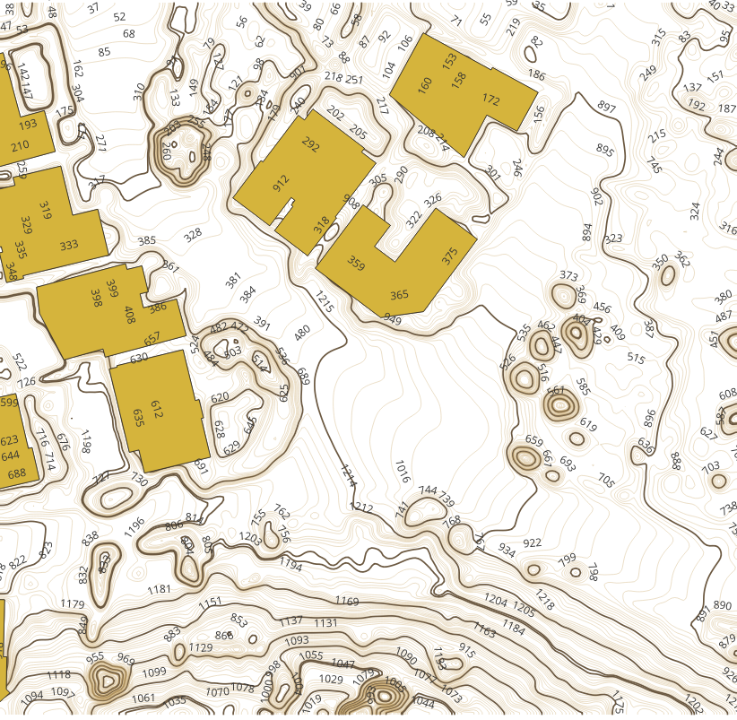
Construction and Engineering

Construction firms and civil engineers depend on our topographical mapping and base mapping for site design, grading plans, and construction management. Engineers can query geospatial data to extract elevation values at specific locations and generate visual representations of proposed grading.

real estate flat icon

Real Estate and Property Management

Drones equipped with advanced imaging technologies can capture detailed and precise data, improving the accuracy of inspections. High resolution cameras and thermal sensors provide utility companies with high quality data for accurate analysis, enabling better decision making and more effective maintenance planning for electrical infrastructure.

environmental flat icon

Environmental Management

Environmental consultants and resource agencies use our LULC mapping and geological mapping to assess habitats and track land cover changes. Organizations can analyze spatial data to identify patterns in environmental change and assess threats like flood zones and earthquake-prone areas.

government flat icon

Government Agencies

Local, state, and federal agencies rely on our GIS mapping services for infrastructure management, emergency planning, regulatory enforcement, and public information. Government users can share map data across departments, enabling collaboration and improving service delivery.

logistics flat icon

Transportation and Logistics

Transportation agencies and logistics companies use GIS to map, analyze, and improve delivery routes to reduce fuel costs and mitigate transportation disruptions. Advanced GIS tools can simulate scenarios such as predicting traffic flow changes due to new highway constructions.

Start Your GIS Mapping Project Today

Tell us about your mapping needs and receive a detailed proposal within 24 hours.