Table Of Contents
Choosing between LiDAR and photogrammetry can significantly impact the accuracy, cost, and efficiency of your next survey or mapping job. Both technologies are widely used in industries like construction, land development, utilities, forestry, and real estate—but they serve very different purposes.
LiDAR uses laser pulses to capture ultra-precise elevation data, even through dense vegetation. Photogrammetry creates 2D and 3D models from high-resolution drone images. So, which one delivers the results you need?
In this guide, you’ll discover:
- How LiDAR and photogrammetry actually work
- Which is more accurate under real-world conditions
- The cost, tools, and expertise required for each
- Best-fit use cases and environmental considerations
- When and why you might combine both methods
If you’re evaluating tools for aerial mapping or survey-grade accuracy, this breakdown will help you make a confident, informed decision.
What Is LiDAR and How Does It Capture Data with Precision?
LiDAR (Light Detection and Ranging) is a high-precision remote sensing method that uses laser pulses to calculate exact distances to the Earth’s surface.These laser pulses bounce off the Earth’s surface and return to the LiDAR sensor, enabling the system to calculate distance based on the time it takes for each pulse to return.
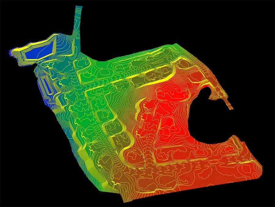
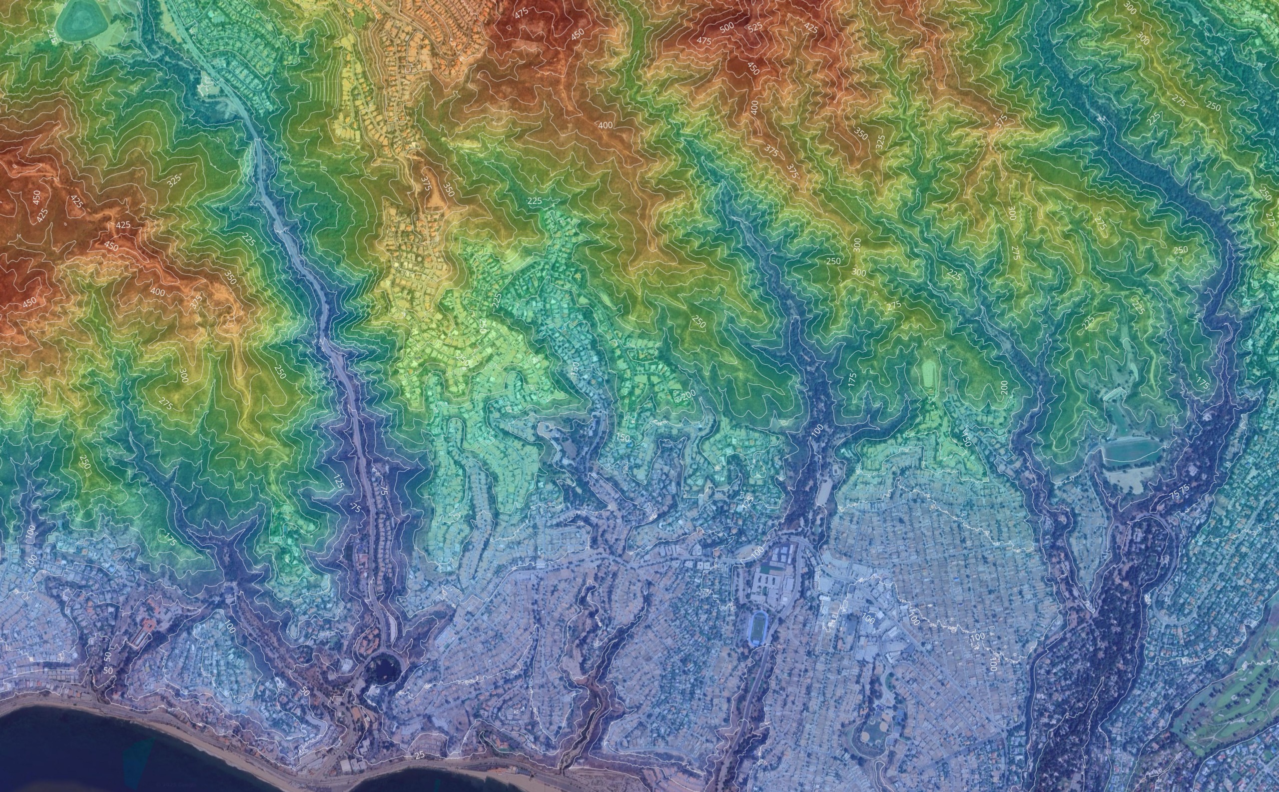
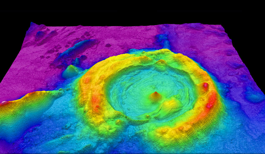
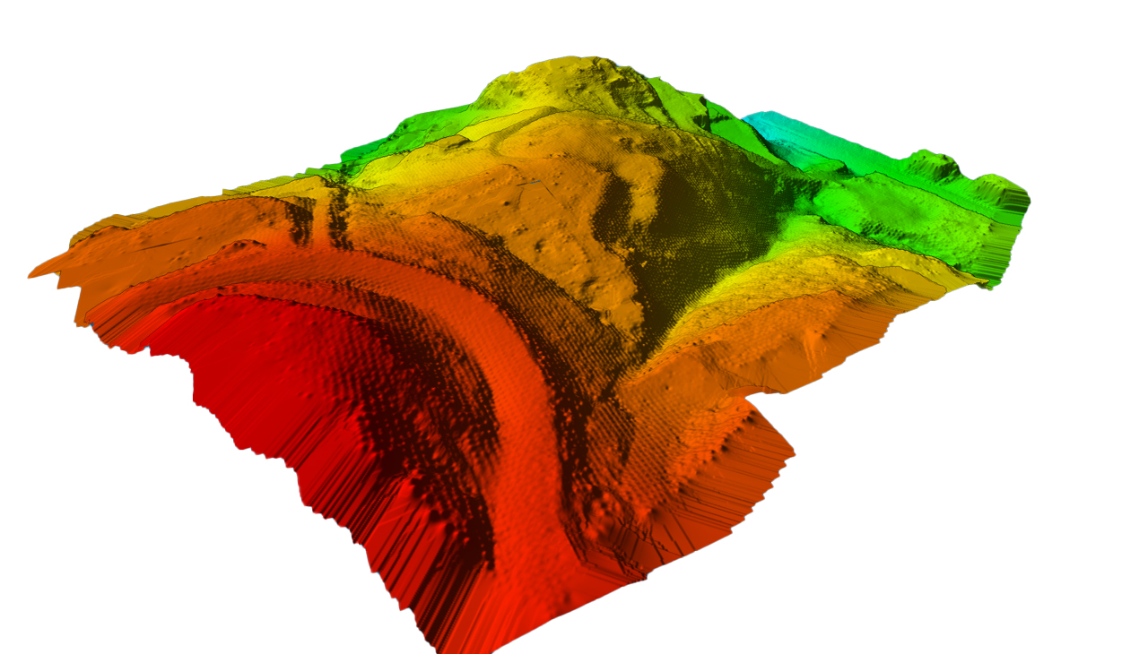
When mounted on a drone, airplane, or ground-based unit, LiDAR generates dense point clouds—collections of geospatial coordinates that represent the terrain and objects below. These are then processed into digital terrain models or digital surface models, depending on whether the data captures bare earth or vegetation and structures.
How Does LiDAR Work?
LiDAR systems emit tens of thousands of laser pulses per second. The reflected signals are received by the sensor, which calculates the distance of each object or surface point. Combined with GPS and IMU (inertial measurement unit) data, LiDAR produces an extremely accurate geospatial dataset.
Key components of a drone-based LiDAR system include:
- A LiDAR scanner or emitter
- A high-precision GNSS receiver (for geotagging)
- An IMU to track position and orientation
- A camera sensor (optional) for colorization or image overlays
Advantages of LiDAR in Surveying
- Direct measurement: LiDAR measures the distance to the ground directly, rather than estimating it through photogrammetric triangulation.
- Works in dense or sparse vegetation: LiDAR pulses can penetrate foliage, making it ideal for forestry, environmental surveys, and mapping under canopy.
- High point density: Some systems produce over 300 points per square meter, capturing subtle variations in terrain.
- Vertical accuracy: Survey-grade LiDAR systems often achieve vertical accuracy within 2–3 cm when combined with RTK or PPK correction.
This makes LiDAR the go-to technology for professionals who require precise topographical data in difficult or variable environments.
What Is Photogrammetry and When Should You Use It?
Photogrammetry is a mapping method that uses overlapping images captured from drones or aircraft to reconstruct detailed 2D and 3D models of the Earth’s surface. Unlike LiDAR, which uses an active sensor to directly measure distances, photogrammetry relies on image geometry and triangulation to infer elevation and surface features.
With drone photogrammetry, hundreds of high-resolution images are captured during a flight, typically with 75–85% image overlap. These are processed into accurate orthomosaic maps, point clouds, or 3D textured meshes using specialized software.
How Photogrammetry Works
Photogrammetry extracts spatial measurements by analyzing the relative position of pixels across overlapping images. The result is a georeferenced dataset that can include:
- Topographic features such as slopes and contours
- Visual data like color, texture, and structure
- Photogrammetric data for engineering or inspection workflows
The accuracy of the output depends on several flight parameters, including altitude, camera quality, and ground control points. In ideal conditions, photogrammetry excels in producing accurate results for mapping open, well-lit areas.
Advantages of Photogrammetry
- High-resolution visual data: Offers photorealistic models ideal for client presentations, real estate, and inspections.
- Cost-effective: Requires only a camera-equipped drone—no need for expensive LiDAR scanners or sensors.
- Flexible and scalable: Suitable for large-scale topographical maps or small property surveys.
- Rich datasets: Includes both spatial and visual information, making it easy to detect objects and analyze surface changes.
While photogrammetry is impacted by environmental factors such as lighting and shadows, it’s ideal for clear, open areas where high accuracy and image quality are priorities.
LiDAR vs Photogrammetry: Key Differences at a Glance
| Factor | LiDAR | Photogrammetry |
|---|---|---|
| Data Type | 3D point cloud from direct laser measurement | 2D/3D model from overlapping images |
| Sensor Type | Active sensor (laser-based); supports orthomosaic mapping | Passive sensor (camera imagery) |
| Accuracy | High — 1–3 cm vertical accuracy with RTK/PPK | Moderate to high — 3–10 cm accuracy with GCPs |
| Vegetation Penetration | Excellent — penetrates canopy, captures bare earth | Limited — captures top surface only |
| Visual Data | No color or texture by default | Rich visual data with color and texture |
| Data Acquisition Speed | Fast — collects dense lidar data in a single flight | Slower — requires many images with high overlap |
| Environmental Sensitivity | Performs in low light or cloudy conditions | Impacted by lighting, shadows, and reflectivity |
| Processing Time | Faster post-processing of lidar point cloud | Slower due to photogrammetric data stitching |
| Hardware Requirements | High-end gear: lidar sensor, GNSS, IMU | Low-cost: drone with camera sensor |
| Output Types | Digital terrain models, contours, elevation maps | Orthomosaics, 3D models, textured surfaces |
| Use Cases | Topographic surveys, utilities, forestry, mining | Construction, real estate, agriculture, inspections |
Both LiDAR and photogrammetry offer powerful solutions for aerial mapping, but they serve different project needs. If your goal is to generate a high-density lidar point cloud in environments with sparse vegetation or under tree canopy, LiDAR delivers unmatched vertical accuracy and precision. On the other hand, drone photogrammetry provides rich visual data and cost-effective workflows for applications like construction monitoring, real estate marketing, and large-scale topographical maps.
Your decision should come down to the required level of detail, environmental conditions, and your available tools for data acquisition and processing.
Which Mapping Method Is More Accurate?
When precision is critical, understanding the accuracy differences between LiDAR and photogrammetry is essential. While both technologies can deliver accurate results, their performance depends on project conditions, hardware, and data processing techniques.
LiDAR Accuracy
LiDAR captures lidar data through direct measurement, making it highly accurate—even in challenging environments. When paired with RTK or PPK correction, modern drone LiDAR systems achieve:
- Vertical accuracy: 2–3 cm
- Horizontal accuracy: ~2 cm (depending on GNSS setup)
- Point density: 100–300+ points per square meter (higher in low-altitude flights)
This makes LiDAR ideal for detecting subtle topographic features, even through vegetation, and producing survey-grade digital terrain models.
Photogrammetry Accuracy
Photogrammetry accuracy can approach similar levels—under the right conditions. When flights are planned with high image overlap, proper ground control points (GCPs), and optimal lighting, it’s possible to achieve: how accurate is a drone survey,
- Vertical accuracy: 3–8 cm
- Horizontal accuracy: 2–5 cm
- Lower point density than LiDAR, especially in areas with uniform surfaces or vegetation
Since photogrammetry relies on identifying features across multiple overlapping images, environmental factors like shadows, reflective surfaces, and wind can impact precision. Still, for many projects, especially in open environments, photogrammetry provides a reliable balance between cost and performance.
LiDAR vs Photogrammetry: Cost, Workflow, and Data Capture
Choosing a mapping method isn’t just about accuracy — it also comes down to budget, tools, and workflow complexity. Here’s how LiDAR and photogrammetry compare in terms of cost and data acquisition.
Cost of Equipment and Tools
| Category | LiDAR | Photogrammetry |
|---|---|---|
| Drone Hardware | Expensive: Requires LiDAR unit + GNSS/IMU | Affordable: Camera-equipped drone |
| Sensor Type | High-cost lidar sensor | Standard camera sensor |
| Processing Software | Proprietary & advanced | Open-source & commercial options (e.g., Pix4D) |
| Operational Costs | Higher (skilled operators + post-processing) | Lower (simpler flights and faster deployment) |
LiDAR systems often require licensed surveyors or specialists to handle calibration and post-processing. Meanwhile, drone photogrammetry is accessible for small businesses, startups, and in-house teams with basic drone training. LiDAR systems can cost between $50,000 to $350,000 depending on the complexity and capabilities of the equipment. A high-end photogrammetry system typically costs between $20,000 and $30,000.
Data Acquisition and Capture Workflow
In LiDAR surveys, the system collects data continuously through laser pulses, delivering highly accurate point clouds even in motion. It’s ideal for fast, large-area scans — especially when terrain elevation changes quickly.
Photogrammetry, by contrast, involves capturing hundreds of overlapping images, then aligning them in post. It’s more sensitive to flight height, speed, and lighting conditions, but it allows detailed visual reconstructions.
Key comparison points:
- LiDAR excels at data capture in real-time.
- Photogrammetry depends more on flight planning, image overlap, and data acquisition precision.
Best Use Cases for LiDAR and Photogrammetry in Real-World Projects
Choosing between LiDAR and photogrammetry isn’t just about specs — it’s about context. Certain environments, project goals, and constraints will determine which method delivers the best outcome, especially when considering advancements such as drone photography in fields like real estate.
LiDAR Excels in Complex Environments
LiDAR’s ability to capture direct measurements through laser pulses makes it ideal for complex environments where terrain is uneven, obscured, or hard to access. The combination of RTK/PPK positioning and high-frequency data capture ensures precise models even when traditional methods fall short.
Best suited for:
- Utility corridor mapping (power lines, pipelines)
- Road and bridge engineering
- Surveying urban infrastructure with varied elevation
Heavy Vegetation and Forestry Applications
One of LiDAR’s greatest advantages is its ability to penetrate vegetation and return accurate data on both the canopy and the ground surface. This makes it the gold standard for forestry applications and environmental studies.
Use cases include:
- Estimating biomass and tree height
- Creating digital terrain models under dense canopy
- Watershed and erosion modeling in forested regions
In contrast, photogrammetry struggles in heavy vegetation, as the camera only captures visible surfaces. Shadows, overlapping branches, and wind can distort results.
Photogrammetry for Large Scale Topographical Maps
When you need large-scale topographical maps with high-resolution imagery, drone photogrammetry is often the more efficient option. With a properly planned flight and sufficient image overlap, photogrammetry can cover vast areas at lower cost, while delivering clear, annotated outputs.
Ideal for:
- Land development & site planning
- Construction monitoring
- Agriculture and crop health assessments
- Surveying arid or open landscapes
It also provides rich visual data, making it the preferred method for marketing visuals and stakeholder presentations.
How Environmental Factors Impact Mapping Accuracy
No matter how advanced the technology, your data quality ultimately depends on the environment you’re mapping. Both LiDAR and photogrammetry respond differently to light, weather, terrain, and other environmental factors.
Lighting Conditions
- Photogrammetry relies on good lighting. Cloud cover, low sun angles, or shadows can affect image quality and lead to stitching errors or poor texture detail.
- LiDAR, on the other hand, is an active remote sensing system—it generates its own signal. That means it works in overcast, low-light, or even night conditions with no loss of performance.
Verdict: LiDAR wins in low-light or high-contrast lighting situations.
Surface Texture and Reflectivity
- Photogrammetry struggles with uniform or reflective surfaces such as glass, water, or snow. It needs surface features to identify tie points across overlapping images.
- LiDAR is less impacted by reflectivity, though it may have issues with absorbing surfaces like black roofs or water.
If the project area has snow, glass structures, or ponds, LiDAR provides more reliable data acquisition for drone operations. For more on risk management, see drone insurance.
Wind, Motion, and Vibration
- Flight parameters like drone speed and gimbal stability directly affect photogrammetry. Blurred images due to wind or vibration lead to reconstruction errors.
- Aerial LiDAR systems collect tens of thousands of data points per second and are more tolerant of drone motion or minor instability.
For drone surveying in windy conditions or on tight flight paths, LiDAR provides more consistent results.
Terrain Complexity
- Uneven ground, steep slopes, and mixed elevations can distort photogrammetric reconstructions, especially if GCPs aren’t used.
- LiDAR captures true elevation and topographic features regardless of terrain shape, making it ideal for digital terrain model creation.
In rugged or mixed-elevation areas, LiDAR ensures higher vertical accuracy and consistency.
LiDAR and Photogrammetry: Which Survey Method Should You Choose?
Whether you’re building a road, mapping a forest, or inspecting a construction site, both drone surveying methods—LiDAR and photogrammetry—have advantages. But the right choice depends on the accuracy requirements, terrain, budget, and your team’s skill level.
When to Use LiDAR
LiDAR is ideal when your project demands:
- Bare ground underneath thick vegetation (e.g. forest floor, flood zones)
- Accurate elevation data across uneven terrain
- Direct data collection in low-light or weather-variable conditions
- Minimal reliance on visual cues or surface texture
- Projects that require high vertical and horizontal accuracy
Because LiDAR delivers accurate information through direct measurement, it’s best for professionals working in forestry applications, large-scale infrastructure, or any site with thicker vegetation and bare ground visibility challenges.
Note: LiDAR requires more advanced equipment and sometimes extensive training for setup and data interpretation.
When to Use Photogrammetry
- Detailed photogrammetric imagery for inspections or marketing
- Color-rich visuals to detect objects or monitor progress
- Cost-effective surveying of open land or bare ground
- Projects where multiple photos can be captured in good lighting
- Applications where visual output matters more than terrain penetration
Photogrammetry is based on image triangulation, so it performs best in flat, unobstructed areas. It’s perfect for flight lines over agricultural fields, construction zones, or real estate.
Pro tip: While photogrammetry lidar combinations are emerging, most drone surveys use one or the other based on the mission scope.
Final Thoughts on Drone Surveying Methods
In the end, there’s no universal “better” method—just the best-fit technology for your specific conditions. Many survey professionals now use both photogrammetry and LiDAR in complementary workflows: LiDAR for terrain modeling, and photogrammetric imagery for textures and visual detail.
If your survey site has bare ground, forest cover, or demands sub-3 cm horizontal accuracy, LiDAR might be the right call. For projects focused on surface visuals or budget-conscious data collection, photogrammetry excels.
Frequently Asked Questions: LiDAR vs Photogrammetry
Is LiDAR considered photogrammetry?
No — LiDAR is not a form of photogrammetry, although both are used for 3D mapping. LiDAR is an active remote sensing technology that uses laser pulses to measure distance directly. Photogrammetry is a passive method that relies on analyzing overlapping images taken from different angles to reconstruct 3D models.
While both methods can produce topographic maps or elevation models, they use very different sensors, processing techniques, and data types.
Is photogrammetry obsolete?
Not at all. Drone photogrammetry remains one of the most widely used and accessible mapping methods today. While LiDAR has advantages in terrain penetration and raw precision, photogrammetry continues to evolve, offering high-resolution visuals, powerful reconstruction software, and cost efficiency.
In industries like construction, real estate, and agriculture, photogrammetry is often preferred due to its lower cost and visual output.
Is photogrammetry cheaper than LiDAR?
Yes. In most cases, photogrammetry is significantly cheaper than LiDAR. A typical photogrammetry workflow requires only a drone with a good camera, proper flight planning, and processing software like Pix4D or DroneDeploy.
LiDAR, in contrast, involves high-end equipment such as a lidar sensor, RTK/PPK GNSS units, and advanced post-processing tools. It also often requires more specialized training and field experience, which can add to project costs.
Is there anything better than LiDAR?
LiDAR is currently one of the most accurate technologies for airborne data collection, especially in complex or forested environments. That said, some hybrid workflows that combine LiDAR and photogrammetry are proving even more effective. These deliver both accurate terrain data and visual context in a single survey.
So while nothing universally “beats” LiDAR, the best solution may be a combined approach, depending on your project goals.
How accurate is drone photogrammetry?
Drone photogrammetry can achieve horizontal accuracy in the range of 2–5 cm, and vertical accuracy within 3–10 cm, depending on conditions. Accuracy depends on:
- Image resolution and quality
- Flight height and speed
- Use of GCPs or RTK positioning
- Environmental conditions (e.g., lighting, wind)
With careful planning and high image overlap, drone photogrammetry can produce results that meet professional-grade survey requirements—particularly in open, unobstructed environments.
What affects horizontal accuracy in drone surveying?
Several factors influence horizontal accuracy in drone-based mapping:
- Sensor quality (camera or LiDAR)
- GNSS signal correction (RTK vs non-RTK)
- Ground control point placement and accuracy
- Environmental conditions like wind and vibration
For drone surveying projects that require consistent, sub-decimeter positioning, using RTK-enabled drones or aerial lidar systems with geospatial correction is essential. Otherwise, small positional shifts can distort the final map or model.