Drone Surveying: Transforming Modern Mapping & Land Analysis
Precision Aerial Surveys for Land Development & Construction
At AeroViews, we provide high-accuracy drone survey services using LiDAR scanning, photogrammetry, and topographic mapping. With over a decade of experience in drone-based aerial surveys, we deliver cost-effective, efficient, and highly detailed site analysis for construction, land development, and infrastructure projects.
Unlike traditional surveying methods, drone surveys offer faster data collection, improved accuracy, and lower costs, making them the preferred choice for engineers, developers, and environmental consultants.

The Future of Surveying is in the Sky
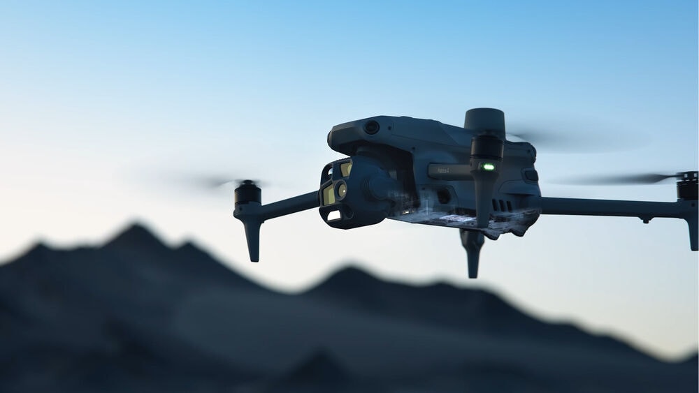
The land surveying industry has undergone a significant transformation with the adoption of drones (UAVs), revolutionizing the way topographic mapping, construction planning, and site analysis are conducted. Traditional land surveying methods, while highly accurate, often require extensive manpower, expensive equipment, and long field hours. In contrast, drone-based surveying offers faster, more cost-effective, and highly detailed data collection, making it the preferred solution for a wide range of industries.
As advancements in RTK (Real-Time Kinematic) GPS, LiDAR sensors, and high-resolution photogrammetry continue to improve drone accuracy, industries such as construction, agriculture, real estate, and mining are increasingly adopting UAV-based solutions to streamline their operations.
The Future of Drone Surveying
Revolutionizing Land and Property Surveys with Drone Technology
Drone surveying is transforming the way land and property surveys are conducted, offering a faster, safer, and more cost-effective alternative to traditional methods. By using high-resolution aerial imaging, LiDAR scanning, and photogrammetry, drones provide precise topographic data, 3D terrain models, and volumetric measurements with centimeter-level accuracy.
In industries such as construction, real estate, and infrastructure development, the demand for drone land surveying is rapidly growing. Unlike traditional survey crews that require ground access and extensive setup, drones can capture large-scale survey data in a fraction of the time, reducing costs and minimizing disruptions.
Why Drone Surveying Matters
The adoption of drone property surveys is not just about speed—it’s about accessibility, accuracy, and safety. Businesses that rely on aerial mapping and site analysis benefit from:
- Faster Data Collection – Drone surveys cover large areas in minutes instead of days.
- Improved Accuracy – Advanced sensors such as LiDAR and RTK GPS ensure precision.
- Enhanced Safety – Reduces the need for surveyors to access hazardous or remote locations.
- Cost Savings – Eliminates expensive manual surveying equipment and labor-intensive processes.
What Is Drone Surveying?
Defining Drone Surveying
Drone surveying is the process of collecting high-precision aerial data using UAVs (Unmanned Aerial Vehicles) equipped with LiDAR, photogrammetry, and GPS technology. This method allows for the efficient and accurate mapping of land, property, and infrastructure, reducing the time and cost associated with traditional land surveying.
By capturing high-resolution imagery and elevation data, drone land surveying provides a detailed and scalable solution for industries such as construction, real estate, agriculture, and environmental management.
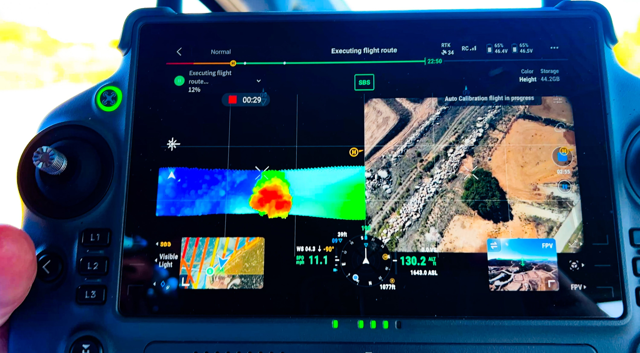
How Drone Surveying Works
Drone surveys utilize advanced sensors and imaging technologies to generate topographic maps, 3D terrain models, and volumetric measurements with centimeter-level accuracy. The process typically involves:
- Flight Planning – Defining survey parameters, including altitude, overlap, and data capture points.
- Aerial Data Collection – UAVs equipped with LiDAR, RGB cameras, or multispectral sensors capture imagery and elevation data.
- Data Processing & Analysis – Specialized software converts raw aerial data into georeferenced maps, 3D models, and elevation profiles.
With RTK (Real-Time Kinematic) GPS correction and LiDAR-based point cloud data, drone surveying produces survey-grade accuracy suitable for engineering, land development, and geospatial analysis.
Key Applications of Drone Surveying
| Survey Type | Use Cases |
|---|---|
| Drone Land Surveying | Property development, zoning, and boundary assessments. |
| Drone Property Surveys | Real estate mapping, construction site analysis, and insurance claims. |
| General Drone Surveys | Agriculture, mining, and environmental assessments. |
- Drone land surveying is widely used for subdivision planning, terrain modeling, and infrastructure development, helping developers and civil engineers make informed decisions.
- Drone property surveys assist real estate professionals, contractors, and insurers by providing high-resolution aerial imagery and site analysis for valuations, planning, and risk assessments.
- General drone surveys are essential for precision agriculture, mineral exploration, and environmental monitoring, enabling businesses to track land conditions, crop health, and resource management.
Benefits of Drone Land Surveying vs. Traditional Methods
How Drone Surveying Improves Efficiency, Accuracy, and Safety
Drone land surveying is revolutionizing real estate and infrastructure planning by offering faster, more accurate, and cost-effective solutions compared to traditional surveying methods. By utilizing high-resolution aerial imagery, LiDAR, and GPS-based mapping, drones can collect and process data in hours rather than days or weeks, reducing project costs while improving safety.
Below is a direct comparison of drone surveys vs. traditional land surveying across key factors:
| Factor | Drone Surveying | Traditional Land Surveying |
|---|---|---|
| Accuracy | 1-3 cm precision with LiDAR and RTK GPS | Highly accurate but requires more time |
| Time Efficiency | Hours to complete large-scale surveys | Can take days or weeks to cover the same area |
| Cost | Lower operational costs with reduced labor needs | Higher labor costs due to manual data collection |
| Safety | No need for surveyors to access hazardous terrain | Risk of injury in rough or hard-to-reach areas |
Why Industries Are Adopting Drone Property Surveys
Drone property surveys allow for detailed 3D mapping of homes, commercial properties, and land boundaries, providing high-resolution imagery that enhances real estate evaluations, site planning, and insurance assessments. Developers, civil engineers, and surveyors benefit from:
- Faster project timelines with real-time aerial data collection.
- Greater site accessibility for hard-to-reach or hazardous locations.
- More detailed geospatial analysis for urban planning and land development.
Types of Drone Surveys & Their Uses
Drone surveying has revolutionized land development, property management, construction, agriculture, and mining by offering high-accuracy aerial data collection. Different industries rely on drone technology to improve efficiency, reduce costs, and gain detailed insights into land and infrastructure projects.
Drone Land Surveying
Drone land surveying is essential for property line verification, land development planning, and zoning compliance. By using LiDAR and photogrammetry, drone surveys provide high-resolution elevation models that help engineers, surveyors, and developers make informed decisions.
Key Benefits:
- Accurate boundary assessments for property division and land disputes.
- Topographic mapping for land grading, drainage planning, and construction feasibility.
- Zoning and compliance verification to meet local government regulations.
According to USGS Land Survey Guidelines, aerial surveys play a critical role in large-scale land development and infrastructure planning.
Drone Property Surveys
Drone property surveys provide high-resolution imaging and 3D models for real estate, construction, and insurance applications.
| Industry | Use Case |
|---|---|
| Real Estate & Insurance | Creates detailed property assessments for valuations, damage reports, and claims processing. |
| Construction | Tracks project progress, material usage, and site planning with accurate geospatial data. |
Why It Matters:
- Real estate professionals use drone surveys for marketing, property inspections, and pre-sale evaluations.
- Construction managers rely on drone data to monitor progress, ensure structural integrity, and verify as-built conditions.
- Insurance companies use aerial property surveys for faster, more accurate claims processing after disasters or damage assessments.
Drone Surveying Workflow: How It Works
Drone surveying services produce high-quality land and property data used in real estate, agriculture, and construction. The workflow follows a structured process to ensure accuracy, efficiency, and compliance with industry regulations.
Step 1: Pre-Survey Planning
Before launching a drone survey, careful planning is required to define the project scope, accuracy requirements, and regulatory compliance.
- Define the survey area – Set precise boundaries for data collection.
- Determine accuracy requirements – Choose between photogrammetry, LiDAR, or GPS-based mapping depending on project needs.
- Flight parameter setup – Optimize altitude, image overlap, and sensor calibration for the best results.
- Check weather conditions – Ensure clear skies and low wind speeds for stable flight.
- Airspace regulations – Follow FAA Part 107 guidelines for commercial drone operations in the U.S. (FAA Drone Rules)
Step 2: Data Collection
Drones equipped with high-resolution cameras, LiDAR sensors, and multispectral imaging systems collect precise aerial data for surveying and analysis.
- High-resolution cameras – Capture overlapping images for photogrammetry-based surveys.
- LiDAR-equipped drones – Generate dense point clouds for precise elevation mapping.
- Multispectral & infrared sensors – Provide agricultural and environmental analysis.
Drone surveying ensures efficient data collection while minimizing human effort and on-site risks.
Step 3: Data Processing & Analysis
After data collection, specialized GIS (Geographic Information System) and photogrammetry software process raw imagery into usable survey outputs.
- 2D Orthomosaic Maps – High-resolution aerial maps stitched together for land development and urban planning.
- 3D Models & Point Clouds – Digital terrain models (DTMs) for construction site analysis.
- GIS Data & Elevation Models – Used for zoning, land use planning, and floodplain analysis.
According to Esri’s GIS Mapping Guide, GIS software plays a key role in transforming drone survey data into actionable insights.
Step 4: Deliverables & Reporting
Final deliverables depend on industry-specific needs, but most clients receive:
| Deliverable | Use Case |
|---|---|
| Digital Elevation Models (DEM) | Construction planning, grading, and site preparation. |
| Contour Maps | Land development, zoning, and environmental assessments. |
| 3D Models & Point Clouds | Structural analysis, infrastructure planning, and terrain mapping. |
| Aerial Imagery & Orthomosaics | Real estate marketing, property appraisals, and insurance assessments. |
Survey results are provided in various file formats compatible with GIS platforms, CAD software, and engineering tools.
Engineers, developers, and real estate professionals rely on drone survey reports to streamline decision-making and improve project accuracy.

FAQ’s
How does automating data collection with drones improve surveying accuracy?
Automating data collection with drones significantly improves surveying accuracy by ensuring consistent and precise measurements over large areas. Drones equipped with advanced sensors and lidar technology can collect detailed 2D and 3D data, capturing intricate details of the terrain and structures. This automation reduces human error and enhances data accuracy, making it invaluable for surveying projects that require reliable data to inform land use and construction decisions.
What are the benefits of using lidar technology in drone surveys?
Lidar technology in drone surveys provides high-resolution, accurate data of the earth’s surface, making it an excellent tool for creating detailed maps and digital surface models. This method of data collection captures the intricacies of terrains and built environments, which is essential for accurate surveys and planning. Utilizing lidar enhances the efficacy of professional surveyors by delivering precise data that supports both post-processing analysis and real-time decision-making.
How can lidar and drones facilitate the creation of multispectral maps?
Lidar and drones facilitate the creation of multispectral maps by integrating various sensors that collect data across different wavelengths. This integration allows for detailed land analysis, capturing both visible and non-visible data that provide insights into vegetation health, water bodies, and other natural features. The use of drones ensures quick and efficient coverage of large and diverse landscapes, making it a preferred method for environmental monitoring and resource management.
What role do construction companies play in utilizing automated drone surveys?
Construction companies play a crucial role in utilizing automated drone surveys to enhance project planning and execution. By employing drones for data collection, these companies can access accurate surveys and detailed maps that inform design and construction processes. This approach not only improves data accuracy but also accelerates project timelines by providing timely insights. The combination of lidar technology with drone surveys ensures construction projects are based on reliable data, reducing risks and increasing efficiency.
What advantages does a drone survey company provide for land surveyors?
A drone survey company provides significant advantages for land surveyors by offering efficient and precise drone data collection that enhances the accuracy of surveys. Drones can rapidly capture detailed imagery and topographic relief from various angles, suitable for difficult environments such as mountainous areas or harsh climates. This capability reduces the time and effort required to conduct surveys, ensuring more accurate results and allowing land surveyors to focus on analysis and decision-making.
How do different angles of data collection with drones improve mapping accuracy?
Collecting data from different angles with drones enhances mapping accuracy by capturing comprehensive three-dimensional representations of the surveyed area. This approach allows for the identification of topographic features and terrain variations that might be missed with traditional methods. By integrating views from multiple perspectives, drones create more accurate and finished maps, benefiting projects in many industries including construction, agriculture, and environmental management.
Why is lidar data important in mapping dangerous or mountainous areas?
Lidar data is essential in mapping dangerous or mountainous areas because it provides precise light detection and ranging data that penetrates dense vegetation and captures accurate terrain representations. This technology allows for the creation of detailed maps and three-dimensional models of challenging environments, facilitating safe navigation and planning. The use of lidar-equipped drones enhances safety and efficiency by enabling surveyors to obtain crucial data without exposing themselves to hazardous conditions.
How does a drone survey company’s use of multispectral cameras enhance land surveys?
A drone survey company utilizing multispectral cameras can significantly enhance land surveys by providing detailed data across various wavelengths. This technology captures information about the health and condition of vegetation, soil composition, and water bodies, which is invaluable for agricultural assessments or environmental studies. By offering a comprehensive view of the surveyed area, multispectral cameras enable the creation of nuanced and informative maps, ultimately supporting informed decision-making in numerous industries.
How do ground control points enhance the accuracy of drone maps?
Ground control points (GCPs) are essential for enhancing the absolute accuracy of drone maps. By providing known locations on the earth’s surface, GCPs serve as reference points that allow for precise georeferencing of the data collected during drone surveys. This practice significantly improves the relative accuracy of the resulting maps, ensuring that they reliably represent the terrain and conditions of the surveyed area, thus supporting more accurate surveys.
What are the benefits of using drones over manned aircraft for surveying harsh environments?
Using drones for surveying harsh environments offers several benefits over manned aircraft, including greater safety, accessibility, and cost-effectiveness. Drones can easily navigate dangerous areas and challenging terrains without putting human pilots at risk. They provide high-resolution data and absolute accuracy by getting closer to ground features, allowing for detailed analysis and mapping. Moreover, drones can save time and reduce the cost associated with operating manned aircraft in difficult or remote locations.
How does minimizing lens distortion contribute to the creation of accurate drone maps?
Minimizing lens distortion in drone mapping is crucial for producing accurate maps. Distortion can lead to misrepresentation of the surveyed area’s features, affecting the overall accuracy and reliability of the map. By using calibrated cameras and adjusting camera tilt appropriately, drone operators ensure that the data collected reflects true ground conditions. This attention to detail supports the production of high-quality drone maps, which are essential for planning and analysis across various applications.
Why is absolute accuracy important in mapping dangerous areas?
Absolute accuracy is critically important in mapping dangerous areas to ensure that the data collected reflects the true position and features of the terrain. Accurate maps are necessary for safe navigation and planning, especially in difficult or potentially hazardous locations. By achieving absolute accuracy, surveyors can produce reliable maps that support decision-making processes, enhance safety protocols, and optimize operations in challenging environments.