Drone 3D Mapping Services for Accurate, Scalable Site Data
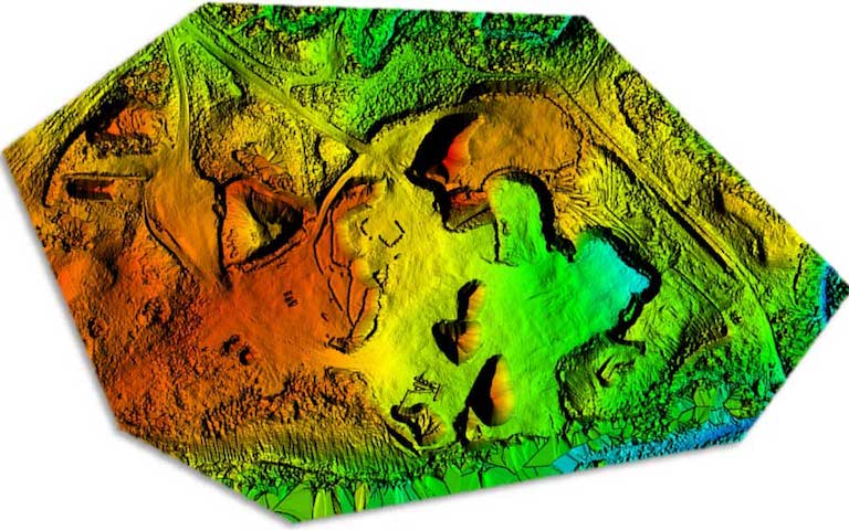
Drone 3D mapping is transforming the way professionals visualize, measure, and manage real-world spaces. By using high-resolution aerial images and advanced photogrammetry software, we generate precise 3D models of buildings, land, infrastructure, and terrain — all without ever setting foot on the structure itself.
At AeroViews, our drone 3D mapping services support industries ranging from commercial construction and land development to agriculture and environmental management. Whether you’re calculating stockpile volumes, planning infrastructure upgrades, or validating site conditions, drone mapping delivers fast, safe, and repeatable data collection.
Unlike traditional ground surveys, drones can cover large or complex areas quickly and generate thousands of overlapping images. These images are then stitched using structure-from-motion photogrammetry techniques — a process recognized by NOAA’s Office of Coast Survey as a reliable method for modern geospatial mapping.
In many cases, we enhance our mapping precision using RTK (Real-Time Kinematic) positioning, or by integrating ground control points (GCPs) to anchor our 3D datasets to real-world coordinates.
If you’re looking for an accurate, scalable way to digitize physical environments, drone 3D mapping is the fastest and most efficient way to get there.
How Drone 3D Mapping Works
Drone 3D mapping transforms raw aerial images into precise, measurable digital models of the built and natural world. By combining high-resolution aerial mapping with advanced software and spatial correction methods, AeroViews delivers results that rival — and often exceed — traditional surveying techniques.
Step 1: Aerial Data Capture
Using pre-planned site planning grids and GPS-locked flight paths, our drones capture hundreds to thousands of images over large areas. These overlapping images (typically 75–85% overlap) ensure every surface and structure is captured in visible light — including an object’s surface geometry, elevation, and context.
Step 2: Ground Control Points & Accuracy
For projects requiring high precision, we use ground control points (GCPs) and RTK/PPK technology to anchor datasets to real-world GPS coordinates. This process enhances accuracy and aligns our 3D outputs with existing GIS, CAD, or engineering systems. It’s the key to generating deliverables with true geospatial relevance. For a technical explanation of these correction methods, Emlid’s RTK guide is an excellent reference.
Step 3: Post Processing & Model Creation
Captured imagery is processed through advanced photogrammetry software like Pix4D or DroneDeploy. These tools create a dense point cloud, which becomes the foundation for outputs like orthomosaic maps, digital elevation models (DEMs), contour lines, and 3D mesh files. For projects involving canopy coverage, we may incorporate sensors to penetrate vegetation or assist with vegetation analysis.
Step 4: Industry-Ready Outputs
Our deliverables are formatted for practical application:
- As-built models for construction and engineering
- 3D mesh and orthomosaics for urban planning, environmental monitoring, or infrastructure inspection
- Crop yields and erosion tracking for agriculture
- Visual progress reports for tracking project progress over time spent
From capturing terrain in remote locations to modeling vertical surfaces with sub-inch resolution, drone-based 3D mapping enables precise measurements and scalable decision-making across multiple industries — faster, safer, and at a fraction of the cost of manned aircraft or traditional crews.
AeroViews handles every part of the process — from flight planning and aerial surveying, to post processing, QA, and final delivery.
Visual Outputs & Deliverables from Drone 3D Mapping
Drone 3D mapping isn’t just about flying a site — it’s about delivering professional-grade outputs that plug directly into your workflows. AeroViews produces a full suite of visual and spatial deliverables designed to meet the needs of construction teams, engineers, planners, and asset managers.
Our Standard Deliverables Include:
1. Orthomosaic Maps
High-resolution, georeferenced 2D maps stitched from aerial imagery. These orthomosaics provide centimeter-level accuracy and are ideal for measuring distances, areas, and changes over time.
2. Point Cloud Data (LAS / LAZ / XYZ)
A dense point cloud is the foundation of 3D modeling. It represents millions of 3D data points across the site — used for volumetric analysis, as-built comparison, and structural modeling.
3. Digital Surface Models (DSM) and Digital Elevation Models (DEM)
We deliver both DSMs (which include buildings and vegetation) and DEMs (bare earth models), giving your team full control over elevation-based planning and analysis.
4. 3D Textured Meshes & Models
Using photogrammetry, we generate 3D textured models that can be viewed, rotated, and annotated. These models are useful for progress tracking, design reviews, and digital twin creation.
5. Contour Maps & Topographic Layers
Contours generated from the point cloud or DSM data are used for grading, hydrology, and cut/fill analysis — essential for civil site planning and land development.
6. Scaled 2D / 3D PDFs and CAD-Compatible Files
We provide export-ready formats including DXF, OBJ, GeoTIFF, and SHP, ensuring compatibility with your AutoCAD, Revit, or GIS software of choice.
These outputs are engineered to align with professional workflows. From as-built documentation to site condition modeling, our deliverables are structured, scalable, and easy to integrate.
Want to see what these look like? Pix4D’s example gallery gives a good idea of the types of visual outputs produced through drone photogrammetry — many of which we deliver at AeroViews.
| Deliverable | Primary Application |
|---|---|
| Orthomosaic Maps | 2D base mapping, site planning |
| Point Cloud Data | 3D modeling, volumetrics, as-builts |
| DSM / DEM | Elevation, grading, drainage design |
| 3D Mesh Models | Visual inspections, digital twins |
| Contour Maps | Topography, cut/fill analysis |
| CAD-Compatible Files | Import to CAD/GIS platforms |
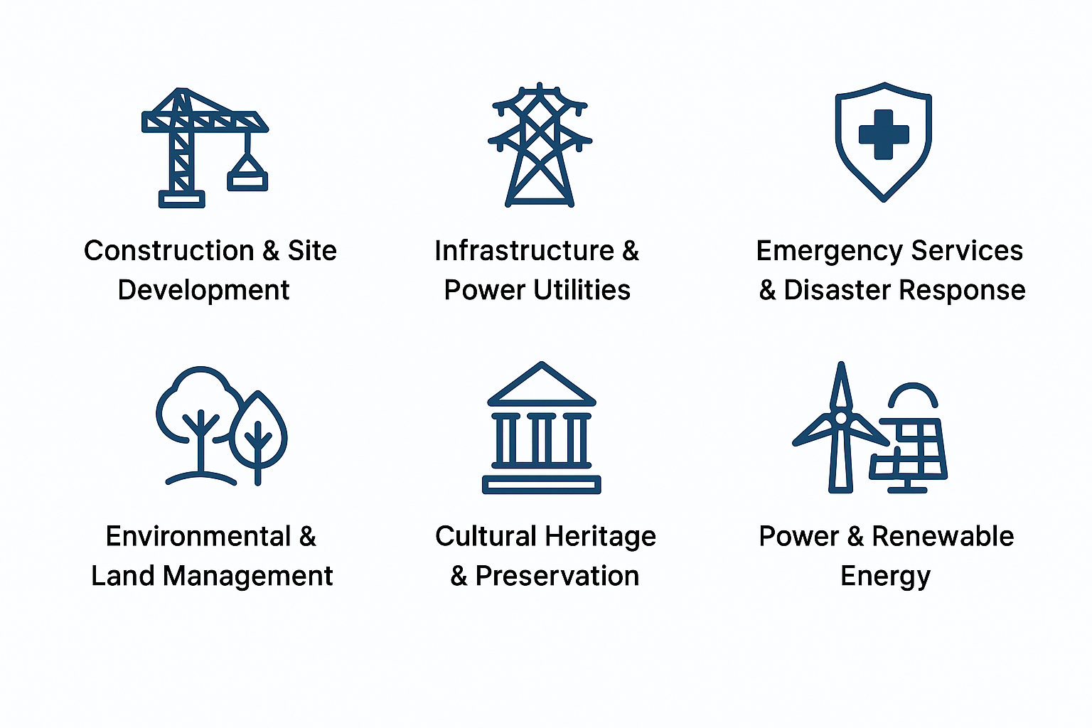
Industries That Benefit from Drone 3D Mapping
Drone 3D mapping unlocks actionable insight across a range of sectors by delivering fast, scalable, and georeferenced drone data. Whether it’s ground-level terrain or vertical infrastructure, AeroViews provides fully capable solutions that are safe, cost-effective, and precise.
Construction & Site Development
From pre-construction terrain models to as-built documentation, drones help contractors reduce rework and stay on schedule. Developers use mapping data to assess land features and track real-time progress throughout the build cycle — without stopping work on site.
Infrastructure & Power Utilities
Mapping supports inspection and monitoring of roads, bridges, pipelines, and transmission towers. With minimal risk to personnel, drones provide detailed models of critical assets, ideal for air-based assessments in high-voltage or inaccessible zones.
Emergency Services & Disaster Response
Rapid post-event mapping is critical for emergency services responding to floods, wildfires, or infrastructure failure. Drones can be deployed within minutes to generate up-to-date orthomosaics and 3D models for responders to evaluate damage and plan safe entry points.
Environmental & Land Management
Monitor soil erosion, watershed health, or vegetation coverage with precision. Our drone services provide repeatable data for change detection, conservation planning, and environmental permitting. When paired with near-infrared or multispectral sensors, mapping also supports habitat restoration and sustainability efforts.
Cultural Heritage & Preservation
Drones make it possible to capture intricate details of historic structures and archaeological sites without physical contact. 3D modeling supports site preservation, digital archiving, and even virtual tourism. We are fully insured, ensuring project compliance in sensitive or federally protected areas.
Power & Renewable Energy
Solar farms, wind installations, and substations benefit from high-resolution 3D data for maintenance and planning. From layout optimization to detecting panel obstructions, drone mapping adds long-term value across the entire power infrastructure lifecycle.
Public Works & Government Users
City and county agencies use drone mapping for urban planning, inspections, and air quality research. For public entities, having fast access to current geospatial data improves decision-making and budget forecasting.
Whether you’re managing a construction site, safeguarding a historic landmark, or restoring post-disaster access — our drone 3D mapping solutions are designed to serve real-world users with clarity, speed, and full accountability.
Frequently Asked Questions About Drone 3D Mapping
What Is Drone 3D Mapping and How Is Aerial Mapping Data Used?
Drone 3D mapping is a process where drones equipped with high-resolution cameras or LiDAR sensors capture aerial mapping data. This data is processed into accurate 3D models, orthomosaic maps, and as-built documentation used in engineering, site planning, and land development. The result is a scalable, georeferenced dataset that improves precision and project timelines.
What’s the Best 3D Mapping Software for Drone Data and Point Clouds?
The top choices for handling drone data and generating dense point cloud files are Pix4Dmapper, DroneDeploy, and RealityCapture. These platforms allow you to generate textured 3D meshes, as-built models, and CAD-ready exports with minimal post-processing time.
How Much Can You Earn Offering Drone Mapping Services?
Earnings from drone services in mapping vary by region, experience, and deliverables. Typical freelance pilots charge $75–$300/hour. Mapping large construction sites or agricultural zones often generates $1,000–$5,000 per project. Operators who provide advanced outputs like orthomosaic maps and volumetrics command higher rates.
What Is the Best DJI Drone for Aerial Mapping and Drone Maps?
The DJI Phantom 4 RTK, Mavic 3 Enterprise, and Matrice 350 RTK (with optional LiDAR) are top-tier options for generating professional drone maps. These drones offer centimeter-level accuracy, support GCP workflows, and integrate with leading processing software — ideal for industries that require large area coverage and fully insured operations.
What Does a Drone 3D Mapping Service Cost for Large Areas?
For large areas, costs range from $500 to $5,000 depending on terrain, mapping detail, and time spent collecting and processing the data. Packages may include orthomosaic maps, point clouds, and as-built overlays. Projects involving restricted airspace or complex environments may cost more due to safety and insurance requirements.
What’s the Difference Between Drone Mapping and a Drone Survey?
A drone survey typically includes geodetic control (e.g. RTK or GCP) and is often used for legal boundary data or engineering-grade accuracy. Drone 3D mapping focuses on terrain visualization, volumetrics, and progress tracking. Both require fully insured operations, especially for commercial clients and public infrastructure projects.
What Drone Services Are Included in 3D Mapping Projects?
Professional drone services for 3D mapping typically include flight planning, ground control point (GCP) placement, aerial image capture, and post-processing. Deliverables often consist of orthomosaic maps, digital surface models (DSMs), and point clouds. At AeroViews, all services are carried out by certified pilots with enterprise-grade drones and full insurance coverage.
What Is an Orthomosaic Map and Why Is It Useful?
An orthomosaic map is a highly accurate, stitched-together aerial image that’s geometrically corrected so every pixel is in its real-world position. Unlike raw drone images, orthomosaics are scale-accurate and can be used for measuring distances, areas, and perimeters. They’re ideal for construction, agriculture, environmental monitoring, and land development.
What Does “As-Built” Mean in the Context of Drone Mapping?
An as-built in drone mapping refers to a 3D or 2D representation of a site or structure after construction or earthwork is complete. It’s used to verify that what was constructed matches the original design. Using drone data, teams can produce visual and measurable as-builts that align with CAD drawings, enhancing accuracy in documentation and billing.
Why Should Drone Mapping Providers Be Fully Insured?
Choosing a fully insured drone service provider ensures protection for both parties in case of equipment failure, property damage, or flight-related incidents. Insurance is particularly critical when flying near buildings, people, or infrastructure — and is often required for municipal, government, or commercial mapping contracts.
How Is Time Spent Calculated for Drone Mapping Services?
Time spent on a drone mapping project is based on multiple factors: site size, terrain complexity, required outputs, and post-processing needs. While smaller sites might require just a few hours of work, large or complex projects can take multiple flight sessions and extensive data processing. Most providers offer flat-rate packages or hourly pricing that reflect this breakdown.