LiDAR Drone Mapping Services in California
AeroViews provides professional LiDAR drone mapping services for engineers, surveyors, developers, and infrastructure teams across California. Using RTK-enabled drones equipped with advanced L1/L2 LiDAR sensors, we capture millions of elevation points per flight — generating highly accurate 3D terrain data with speed and precision.
Our aerial LiDAR systems combine drone efficiency with survey-grade technology, enabling accurate data collection even in dense vegetation, rugged terrain, or hard-to-reach sites. This method is widely recognized by agencies such as NOAA and the USGS as one of the most effective tools for producing detailed surface models.
We deliver CAD-ready point clouds, contour lines, and digital elevation models (DEMs) that integrate seamlessly with engineering and GIS workflows. Whether you’re mapping 10 acres or 10,000, AeroViews consistently delivers results with horizontal and vertical accuracy typically within 2–5 centimeters.
We serve clients across Los Angeles, San Diego, Orange County, Riverside County, San Francisco, and San Jose — combining technical expertise, local knowledge, and rapid turnaround to keep your project moving forward.

What Is LiDAR Mapping Used For?
LiDAR drone mapping is a highly efficient way to collect detailed 3D elevation data across large or challenging areas. It works by sending laser pulses from a drone to the ground and measuring the return time — allowing us to build accurate terrain models, even beneath trees or over rugged surfaces.
At AeroViews, we use LiDAR to support clients across a range of industries that need fast, precise topographic data. Whether it’s for engineering, environmental analysis, or volume tracking, LiDAR delivers high-resolution insights that photogrammetry alone often can’t.
Land Development and Site Planning
Developers and engineers use LiDAR to map terrain, slopes, and drainage conditions before construction begins. Our data helps teams create grading plans, calculate cut/fill volumes, and submit accurate topographic basemaps for permits and design.
Construction and Earthwork QA
We use drone LiDAR to validate that site grading and excavation work matches the design plans. This helps contractors avoid costly rework by catching issues early. With centimeter-level accuracy, we support earthworks, pads, and utility corridors.
Utility Corridor and Infrastructure Mapping
LiDAR is ideal for mapping long, narrow corridors — such as power lines, pipelines, or road alignments. It penetrates vegetation and provides precise ground profiles, enabling teams to assess clearance, right-of-way limits, and terrain for routing.
Environmental and Vegetation Monitoring
Because LiDAR penetrates through tree canopy, it’s used for monitoring forest health, wetland boundaries, and erosion-prone areas. Agencies and consultants use our services to model surface change over time or create vegetation-free digital elevation models (DEMs).
Floodplain and Watershed Analysis
Government agencies and planners use LiDAR data to model runoff, simulate stormwater flow, and evaluate flood risk. Organizations like FEMA and the USGS rely on LiDAR for its proven accuracy in hydrological applications.
Mining, Aggregates, and Volume Measurement
We use LiDAR to calculate stockpile volumes, pit depths, and site contours for quarries and mining operations. This helps with production tracking, safety audits, and compliance reporting — without interrupting work on the ground.
Urban Planning and Infrastructure Design
City planners and civil firms use our LiDAR data for roadway alignments, zoning studies, stormwater management, and utility layout. With CAD- and GIS-ready deliverables, our outputs plug directly into the design process.
LiDAR helps uncover what the eye can’t see — delivering fast, accurate ground models no matter the terrain or vegetation. AeroViews provides this data with industry-grade precision, giving you the confidence to build, design, and plan with total accuracy.
LiDAR vs. Photogrammetry: What’s the Difference?
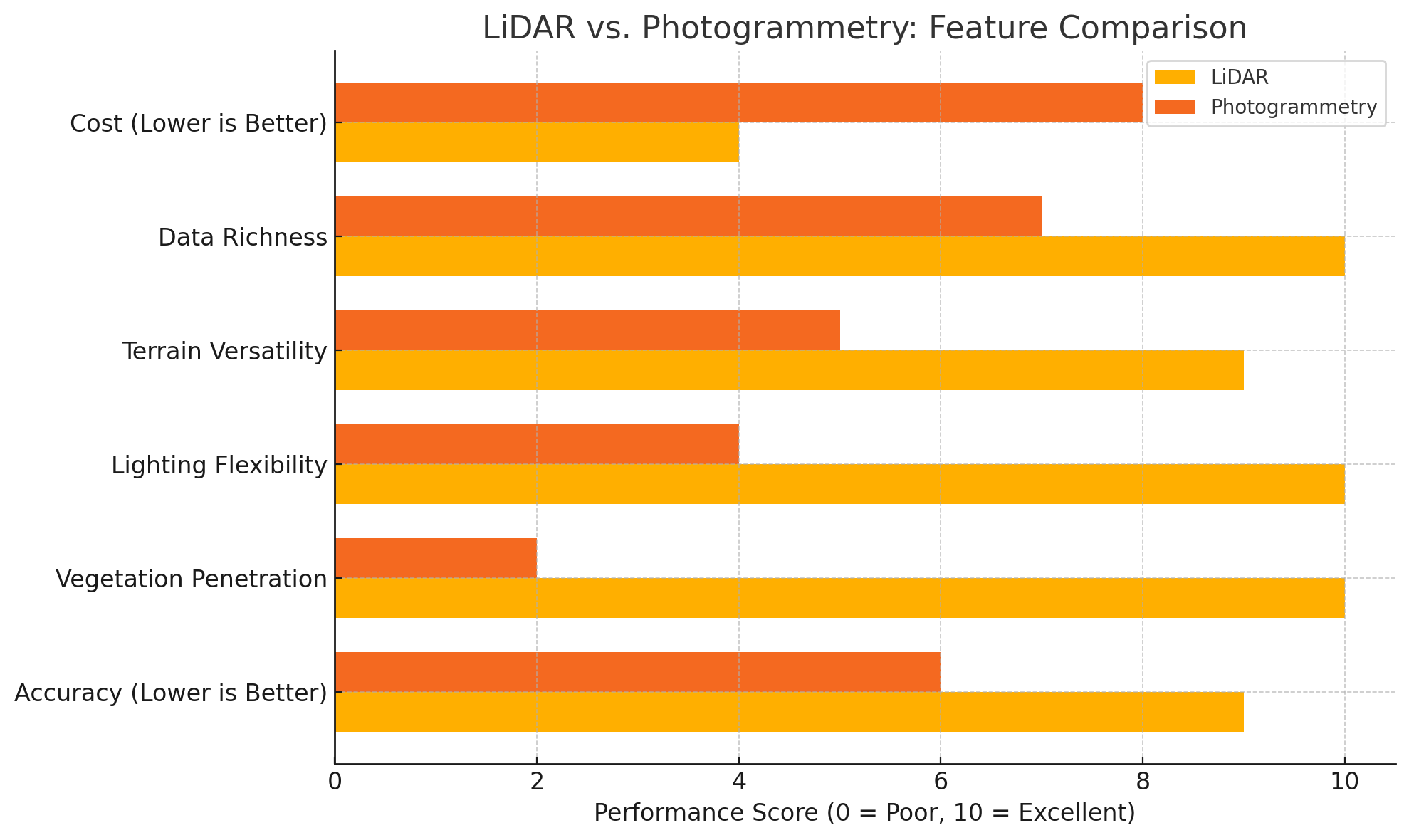
Why Choose LiDAR Over Photogrammetry?
When it comes to mapping the earth’s surface, both LiDAR and photogrammetry offer valuable tools — but they’re designed for different challenges. At AeroViews, we offer both, and help clients select the best method based on the project’s terrain, visibility, and required precision.
Think of it like this: if photogrammetry is like taking a photo of the ground, LiDAR is like reaching out and feeling its exact shape — even if it’s covered in brush, trees, or shadows.
LiDAR Delivers Surface Data in Dense Terrain
Unlike photogrammetry, which creates 3D models from stitched aerial images, drone LiDAR uses laser pulses to directly measure the ground beneath vegetation, shadows, or debris. This makes it the go-to tool for land surveying, forestry, and utility mapping — anywhere accurate surface data is needed in complex environments.
LiDAR sensors on our drones penetrate tree canopies and return precise ground points, which we then process into high-density point clouds and bare-earth digital elevation models (DEMs). These deliverables are ideal for grading, drainage planning, and elevation analysis.
More Reliable in Poor Light or Uneven Conditions
Photogrammetry relies on consistent lighting and visible surfaces. But drone LiDAR works independently of sunlight or surface texture — making it ideal for early morning flights, overcast days, and rough terrain. For projects with tight schedules or sensitive conditions, this flexibility can be a major advantage.
Engineering-Grade Accuracy for Design and Development
Our LiDAR payloads collect critical data with 2–5 cm absolute accuracy (when paired with GCPs). That level of detail supports infrastructure design, transmission line analysis, construction QA, and more. According to the USGS, LiDAR is the preferred method for high-accuracy elevation data collection in engineering and government workflows.
When to Use Photogrammetry
Photogrammetry is still a powerful tool for visual applications — like real estate, roof inspections, or projects where visual texture is more important than elevation. It’s cost-effective and lightweight for quick jobs over open areas.
At AeroViews, we tailor each drone mapping project to your goals — using LiDAR when precision, terrain, and vegetation demand it, and photogrammetry when visual models are the priority. Our team manages the entire data collection workflow, helping you choose the right solution to get the results you need.
How AeroViews Captures and Delivers LiDAR Data
At AeroViews, our drone LiDAR mapping workflow combines advanced technology with field-tested methods to collect precise data — even in hard-to-reach areas. We use state-of-the-art LiDAR sensors and drone platforms to gather high-density data points with just one flight, helping our clients make fast, confident decisions.
Advanced Drone LiDAR Technology and Payloads
We operate RTK-enabled, LiDAR-equipped drones like the DJI Matrice series, paired with high-performance LiDAR payloads such as the DJI L2. These LiDAR systems emit rapid laser pulses to collect data points from the earth’s surface — even under vegetation or between objects like utility lines, tree canopies, and rooftops.
Because we use drones rather than helicopters or manned aircraft, our approach offers greater efficiency, lower costs, and safer data collection in rugged or remote environments.
Precision Mapping Through Smart Flight Planning
Before every mission, we evaluate land use, terrain, and project needs. Depending on your goals, we incorporate aerial drone photogrammetry, virtual reference stations, or ground control points to calibrate the output.
Whether you’re mapping an urban area, an agricultural zone, or a conservation site, we determine the right flight path and data density to achieve accurate, repeatable results.
Fast and Efficient Data Collection
Our drones collect massive amounts of detailed data during a single automated flight. The laser-based LiDAR technology allows us to fly in low-light, overcast, or variable weather conditions — something traditional photogrammetry systems can’t always handle.
For projects involving dense vegetation, individual trees, or transmission corridors, drone LiDAR sensors are far superior to camera-based methods in producing usable surface models.
High-Quality Deliverables for Engineers and Planners
Once collection is complete, we process and classify the LiDAR data using industry-standard workflows. Our deliverables include:
- Classified point clouds (LAS/LAZ)
- Digital elevation models (DEMs)
- Digital surface models (DSMs)
- Contour lines and terrain models
- 3D models of surface features and objects
- Orthomosaics (when RGB data is integrated)
These outputs are compatible with platforms like Civil 3D, ArcGIS, QGIS, and Bentley, and can be tailored for irrigation planning, precision agriculture, conservation efforts, or infrastructure design.
Built for Real-World Demands
Our LiDAR data is already in use across California for emergency response, public safety planning, and infrastructure inspections. Whether you’re modeling urban areas, identifying individual objects, or gathering data points across difficult terrain, AeroViews delivers actionable LiDAR data — quickly, accurately, and with zero guesswork.
Built for Surveyors, Engineers, and Planners
All AeroViews deliverables are formatted to integrate with tools like Civil 3D, ArcGIS, Revit, QGIS, and Trimble Business Center. Whether you’re modeling a site, planning utilities, or tracking earthwork progress, our LiDAR mapping services give you the data you need — fast, accurate, and field-ready.
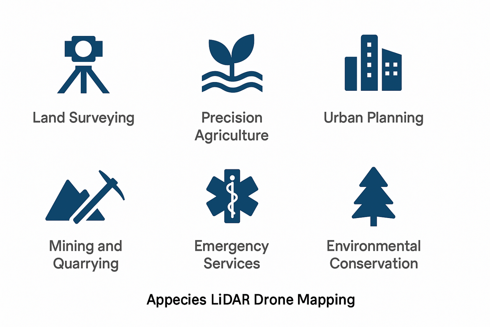
Industries That Benefit from Drone LiDAR Mapping
Drone LiDAR technology is transforming how industries gather, analyze, and act on spatial data. By delivering high-resolution lidar data faster and more efficiently than traditional methods, AeroViews empowers clients across a wide range of sectors — from infrastructure to environmental protection.
Here’s how different industries are using our drone lidar services today:
Mining and Aggregates
In the mining industry, accuracy is everything. Our lidar-equipped drones capture dense point clouds of quarries, pits, and stockpiles — providing reliable volume calculations, site models, and safety assessments. By replacing ground-based measurements with airborne lidar systems, operators reduce risk and gain real-time insights to support planning and compliance.
Public Safety and Emergency Services
First responders and emergency services use drone lidar to generate detailed surface maps of disaster zones, wildfire burn areas, and search-and-rescue sites. Because lidar sensors function independently of light and weather, they can be deployed quickly in dynamic situations. Our radar- and laser-based data helps responders make fast, informed decisions — especially in areas that are unsafe or inaccessible by foot.
Utilities and Infrastructure
We use drone lidar mapping to assess power lines, pipelines, and road networks. Lidar payloads mounted on RTK drones deliver detailed 3D models of ground and infrastructure features — ideal for clearance monitoring, encroachment detection, and right-of-way management. The ability to “see through” trees or brush provides surface-level visibility that photogrammetry systems cannot.
Environmental and Conservation Work
From tree canopy analysis to watershed restoration, lidar mapping plays a critical role in conservation efforts. Agencies use our lidar systems to model topography under vegetation, assess erosion risk, and study habitat boundaries. Emerging uses of water-penetrating green light lidar also show promise for measuring shallow water bodies and wetland zones.
Agriculture and Irrigation Planning
In precision agriculture, drone lidar helps landowners and agronomists analyze terrain, slope, and drainage. This information supports efficient irrigation design, soil management, and infrastructure placement. Lidar-equipped drones provide highly detailed surface data — even under dense crop cover — helping maximize land productivity.
Innovation and New Technology
As lidar sensor drones continue to evolve, new technology applications are emerging every year — from near infrared laser scanning for plant health to multi-layered urban modeling with radar and optical fusion. AeroViews remains at the forefront of these advancements, testing new lidar payloads and software solutions that deliver even more precise and actionable results.
Where We Operate: LiDAR Mapping Across California
AeroViews proudly serves clients across the state of California, providing advanced drone LiDAR mapping services in both urban and rural environments. Whether your project is in a densely built city or a remote agricultural zone, our fleet of lidar-equipped drones is ready to deliver accurate, fast, and field-ready data.
Areas We Serve
We perform LiDAR drone mapping in all major regions including:
- Los Angeles County – Infrastructure, urban planning, and utility corridor mapping
- San Diego County – Coastal erosion studies, construction QA, and flood modeling
- Orange County – Site development, public safety, and precision topography
- Riverside & San Bernardino Counties – Mining, land use, and emergency response
- San Francisco Bay Area – Transportation planning, land surveying, and vegetation mapping
- Central Valley & Agricultural Zones – Irrigation planning, field drainage, and precision agriculture
- Northern California – Conservation efforts, wildfire mapping, and terrain analysis in hard-to-reach areas
Why Our Clients Choose AeroViews
Clients across California trust AeroViews for:
- Responsive turnaround times (often within 48–72 hours for data delivery)
- FAA-certified pilots and licensed LiDAR operators
- Proven accuracy, even in difficult terrain or dense vegetation
- Flexible deliverables — including DEMs, point clouds, 3D models, and CAD-ready files
- On-site GCP collection, RTK setup, and custom coordinate systems
Our LiDAR mapping services are ideal for local governments, engineering firms, environmental agencies, and large-scale developers seeking precise geospatial data without the cost or complexity of traditional surveys.
Frequently Asked Questions About LiDAR Drone Mapping
What is LiDAR drone mapping?
LiDAR drone mapping is the process of using drones equipped with laser-based sensors to capture precise 3D measurements of the Earth’s surface. The drone LiDAR system emits thousands of laser pulses per second, measuring how long it takes each pulse to bounce back. This creates a dense point cloud that models terrain, buildings, vegetation, and more — all with survey-grade accuracy.
What is the best drone for LiDAR mapping?
The best drones for LiDAR mapping are RTK-enabled, heavy-lift platforms that support advanced lidar payloads. At AeroViews, we use the DJI Matrice 350 RTK paired with the DJI Zenmuse L2 — a highly efficient system for precision topographic surveys. This platform offers high flight stability, long battery life, and seamless integration with LiDAR sensors.
Can you add LiDAR to a drone?
Yes, many professional drones are designed to carry modular lidar payloads. However, not all drones are suitable. Adding LiDAR requires a drone with sufficient payload capacity, flight stability, and navigation systems like RTK or PPK. AeroViews uses purpose-built drones specifically configured for lidar mapping to ensure consistent data quality.
How much do LiDAR drone pilots make?
According to industry averages, LiDAR drone pilots earn between $65,000 and $120,000 per year, depending on experience, certifications, and project type. Those with expertise in survey-grade drone lidar mapping — particularly in industries like construction, utilities, and land surveying — can command higher rates.
How much does LiDAR mapping cost?
LiDAR drone mapping typically ranges from $100 to $400 per acre, depending on factors like terrain, vegetation, accuracy requirements, and deliverables (e.g. DEMs, contours, point clouds). AeroViews provides transparent pricing tailored to your site size, accessibility, and data needs — with optional add-ons like GCPs or RGB orthomosaics.
Does Google Maps have lidar data?
Google Maps does not use drone LiDAR for its imagery. While it sources elevation data from satellites and aerial photogrammetry, it doesn’t deliver the dense point clouds or vertical accuracy that true LiDAR technology provides. For engineering, flood modeling, or terrain analysis, dedicated LiDAR mapping is the standard.
What is LiDAR mapping used for?
LiDAR mapping is used for a wide variety of applications including land surveying, infrastructure design, floodplain modeling, vegetation monitoring, precision agriculture, mining, and public safety. It’s particularly valuable in areas with dense vegetation or uneven terrain where traditional mapping falls short.
How accurate is LiDAR mapping?
Drone LiDAR mapping typically achieves 2–5 cm vertical and horizontal accuracy when combined with ground control points or RTK correction. The precision depends on the quality of the LiDAR sensors, GNSS corrections, flight altitude, and processing workflow.
Can you make money drone mapping?
Yes — LiDAR mapping is a growing field with high demand in surveying, engineering, and environmental industries. Professionals offering drone LiDAR services can build profitable businesses by specializing in high-accuracy mapping that supports critical infrastructure, land development, and conservation efforts.
Which DJI drones can do mapping?
DJI offers several drones capable of professional mapping. For photogrammetry, models like the DJI Phantom 4 RTK and Mavic 3 Enterprise are common. For LiDAR mapping, the DJI Matrice 300/350 RTK paired with the Zenmuse L1 or L2 lidar sensors delivers high-precision, large-scale survey capabilities — and is the platform AeroViews relies on.
How is lidar technology revolutionizing land surveying?
Lidar technology is revolutionizing land surveying by providing high-resolution mapping capabilities that significantly increase the accuracy and efficiency of surveys. Unlike traditional methods, lidar sensors capture vast amounts of data quickly, offering detailed insights into landscapes, including elevation changes and surface features. This advancement allows surveyors to create precise three-dimensional models of surveyed areas, making lidar mapping an invaluable tool in various surveying applications.
What are the benefits of using drone lidar in precision agriculture?
Using drone lidar in precision agriculture offers numerous benefits, including the ability to monitor and analyze lands with high precision. This technology provides vital data about crop health, field topography, and soil conditions, enabling farmers to make informed decisions about irrigation, fertilization, and crop planning. The rapid data collection and processing capabilities of drone lidar, especially when combined with platforms like the DJI Matrice, enhance operational efficiency, leading to optimized agricultural practices and increased yields.
How does the DJI Matrice enhance the application of lidar sensors in surveying projects?
The DJI Matrice enhances the application of lidar sensors in surveying projects by offering a robust platform that supports the integration of advanced light detection and ranging technology. Its compatibility with various lidar data systems allows for the capture of precise geospatial information in different environments. The drone’s stability and adaptability make it ideal for land surveying and lidar mapping tasks, ensuring accuracy and reliability in capturing data even in challenging conditions.