Real Estate Drone Photography

Professional aerial photography services for real estate agents and real estate professionals. Stunning aerial photos, drone video, and drone footage that showcase property listings and help properties sell 68% faster. Commercial real estate photography for office building, retail space, and commercial property.

Real Estate Drone Photography
  • FAA Part 107 Certified
  • 68% Faster Sales

  • Same Day Delivery

Traditional Real Estate Photography
Misses the Full Story

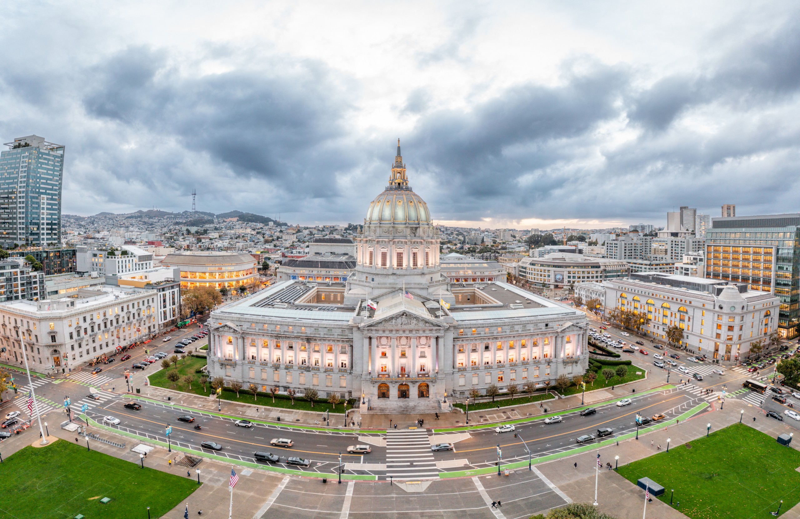
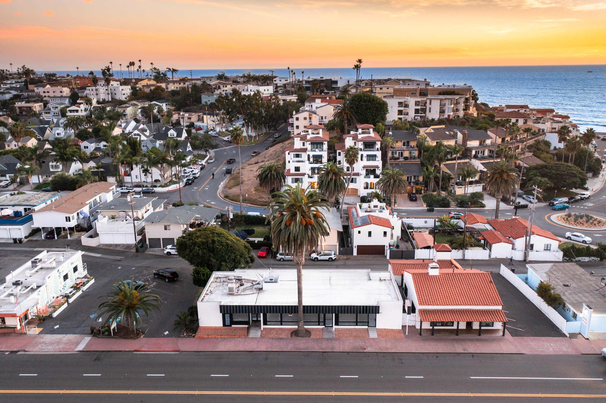
Real estate agents face intense competition in the local market where potential buyers begin their property search online. Traditional ground-level real estate photography fails to capture the entire property, surrounding area, and property’s location within the neighborhood. Without aerial images and aerial shots showcasing the property’s layout, nearby amenities, nearby parks, and outdoor features like swimming pool or lush greenery, property listings struggle to attract potential buyers and stand out in a competitive market.

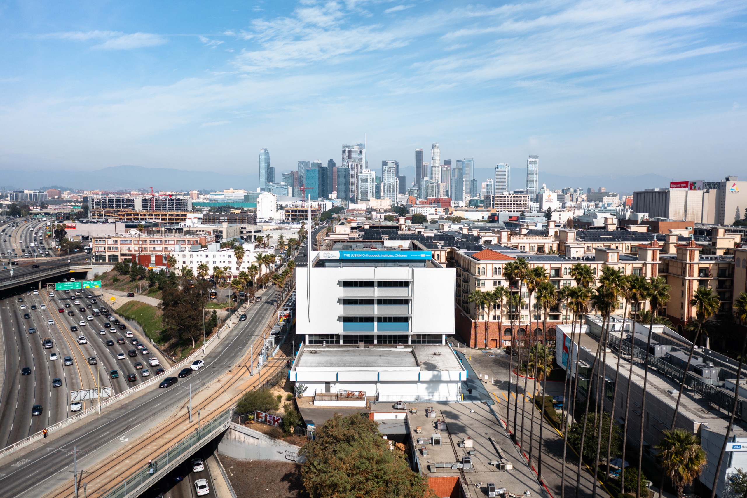
Real estate professionals know that potential buyers purchase a lifestyle as much as a structure, making neighborhood context and surrounding environment critical to real estate marketing. Standard real estate photo packages cannot provide a bird’s eye view of the property’s potential, unique features, or proximity to nearby attractions. Real estate aerial photography is essential for showcasing properties located near waterfront, vacant land with development potential, and commercial real estate like office building or retail space.

In 2026, drone photography has become table stakes for competitive real estate listings. Over 80% of searches are now on mobile devices, making visually appealing content and stunning visuals more important than ever. Without professional aerial photographers capturing aerial imagery and engaging videos, property listings receive fewer clicks online and take longer to attract clients. Real estate agents who fail to utilize drone photography services are missing a proven track record of helping properties sell faster and gain a competitive edge in the real estate industry.

Professional Drone Photography Services

AeroViews delivers comprehensive real estate drone photography and aerial photography services that showcase properties from unique perspective. Our drone photography services include high resolution images, drone video, and drone footage that help real estate agents create property listings that attract potential buyers and sell faster in any weather conditions.

68%

Faster Property Sales

22%

Faster with Dynamic Reveals

10%

Price Increase Potential

24-48hrs

Fast Delivery

Complete Real Estate Aerial Photography Solutions

From residential property listings to commercial real estate photography, our drone photography services provide real estate agents with the aerial images and drone video they need to showcase properties and capture images that attract potential buyers.

residential aerial photography

Residential Aerial Photography

Comprehensive drone photography for residential real estate that captures the entire property from breathtaking perspectives. Our aerial photos showcase unique features, property’s layout, outdoor features, and surrounding area to help real estate professionals create property listings that stand out and attract potential buyers in the local market.

  • High resolution aerial images and aerial shots
  • Bird’s eye view showing property lines
  • Showcase properties with pools, yards, landscaping
  • Capture surrounding environment and nearby amenities

Perfect for: Single-family homes & estates

commercial real estate photography

Commercial Real Estate Photography

Professional aerial photography for commercial property including office building, retail space, and other commercial real estate. Our commercial real estate photography captures property’s location, parking facilities, accessibility, and proximity to business centers, providing real estate agents with aerial imagery that helps commercial property attract clients.

  • Office building and retail space documentation
  • Parking and accessibility visualization
  • Location within business district
  • Comprehensive property overview

Perfect for: Commercial listings & leasing

drone video & drone footage

Drone Video & Drone Footage

Dynamic drone video and engaging videos that provide immersive property tours for potential buyers. Our drone footage includes dynamic reveals that help listings sell up to 22% faster by allowing buyers to explore the property and surrounding area virtually. Aerial videos create emotional connections and help real estate marketing stand out online.

  • 60-90 second showcase videos
  • Dynamic reveals and smooth transitions
  • Aerial footage of property and neighborhood
  • Optimized for social media and virtual tours

Perfect for: Luxury properties & virtual tours

vacant land drone photography

Vacant Land & Acreage

Specialized aerial photography for vacant land that captures the lay of the land and provides potential buyers with a vision for the future. Our drone photography services showcase property boundaries, topography, nearby parks, and surrounding environment to help real estate agents market land parcels and acreage properties effectively.

  • Property boundary visualization
  • Topographic features and terrain
  • Access roads and utilities
  • Development potential showcase

Perfect for: Land sales & development

drone-panorama-example

Photo Editing & Post-Production

Professional editing of aerial photography in RAW format to retain maximum photo properties for best light and quality. Our photo editing services enhance aerial images with color correction, object removal, sky replacement, and professional touches that make property listings visually appealing and help real estate professionals attract potential buyers.

  • RAW format editing for maximum quality
  • Color correction and enhancement
  • Object removal and sky replacement
  • Next-day delivery of edited photos

Perfect for: Professional presentations

twilight drone photography

Twilight Drone Photography

Stunning twilight aerial photography shot in early morning or golden hour to capture properties in the best light. Twilight drone photography creates dramatic, visually appealing images that showcase properties with unique perspective and emotional impact, helping real estate listings stand out and create lasting impressions on potential buyers.

  • Golden hour and blue hour shooting
  • Dramatic lighting and ambiance
  • Enhanced curb appeal presentation
  • Premium listing differentiation

Perfect for: Luxury home marketing

Professional Drone Photography Equipment

We use the best professional aerial photography equipment to ensure high quality aerial images and drone footage for every real estate photography project.

Mavic 2 pro

DJI Mavic 2 Pro

Our minimum standard for real estate drone photography. The Mavic 2 Pro features a Hasselblad camera with 1-inch CMOS sensor, capturing 20MP aerial photos and 4K video with exceptional color accuracy and dynamic range for professional real estate photography.

DJI Mavic 3 Pro

DJI Mavic 3 Pro

Advanced aerial photography capabilities with triple-camera system including wide, medium telephoto, and tele lenses. The Mavic 3 Pro delivers stunning aerial images with incredible detail and flexibility for capturing properties from multiple perspectives in a single flight.

drone mapping icon

DJI Mavic 4 Pro

Our most used drone for real estate aerial photography in 2026. The Mavic 4 Pro offers cutting-edge imaging technology, intelligent flight modes, and superior obstacle avoidance, delivering the highest quality aerial photos and drone video for discerning real estate professionals and their property listings.

Give Your Real Estate Listings
a Competitive Edge

Join 83% of home sellers who prefer real estate agents using drone photography services.

Why Real Estate Agents Choose Aerial Photography

Real estate drone photography delivers measurable results that help property listings sell faster and attract more potential buyers in the competitive real estate industry.

sold faster icon

Properties Sell 68% Faster

Listings with aerial imagery sell 68% faster than those without, making drone photography a valuable investment for real estate professionals. Aerial photos help properties stand out better online with 68% more attention compared to regular photos, attracting potential buyers and leading to faster sales in the local market.

increase property value flat icon

Increase Property Value Up to 10%

Homes featuring aerial imagery can see a price increase of up to 10%. Professional aerial photography creates a comprehensive overview that helps potential buyers appreciate the property’s potential, unique features, and surrounding area, justifying higher asking prices and faster sales for real estate agents.

showcase icon

Showcase Unique Features

Aerial photography provides a comprehensive overview of properties, capturing features like large yards, swimming pool, and nearby parks that traditional photography often misses. Drone photography allows real estate professionals to showcase properties from breathtaking perspectives that help property listings stand out and attract clients.

competitive edge flat icon

Gain Competitive Edge

In 2026, drone photography has become a standard expectation for competitive real estate listings. Utilizing drone technology signals that an agent is modern and tech-savvy, preferred by 83% of home sellers. Real estate agents using aerial photography gain a competitive edge in the real estate industry and attract more listings.

neighborhood context icon

Provide Neighborhood Context

Aerial photography helps unveil the full grandeur of any property, showcasing its property’s location within the neighborhood and proximity to nearby amenities. High-altitude aerial shots establish a property’s place in the broader landscape, helping potential buyers understand the surrounding environment and lifestyle they’re purchasing.

mobile optimized flat icon

Optimized for Mobile Viewing

With over 80% of searches on mobile devices, vertical compositions and stunning visuals are critical for real estate marketing. Our aerial photography is optimized for mobile viewing, ensuring property listings look exceptional on smartphones and tablets where potential buyers discover properties online.

Our Real Estate Photography Process

We make it easy for real estate agents to get professional aerial photography that helps their property listings attract potential buyers and sell faster.

Property Preparation

Prepare the property by tidying up the exterior before the drone photography session. Real estate professionals coordinate with us on shooting schedule, highlighting home’s best features to capture, and discussing surrounding area coverage including nearby amenities and neighborhood context.

Professional Aerial Photography

Our FAA-certified professional aerial photographers conduct the shoot using natural light to capture high resolution images and drone footage. We shoot in RAW format to retain maximum data for professional editing and fly the drone at optimal altitudes to capture detailed views beyond just roof and surroundings.

Expert Photo Editing

Professional editing enhances aerial images and drone video to create visually appealing, stunning visuals that showcase the entire property. Our photo editing includes color correction, object removal where needed, and optimization for both web and print use in property listings and real estate marketing materials.

Fast Delivery

Receive edited aerial photos and drone footage the next day before 5pm EST. Real estate agents get high resolution images ready for property listings, social media, email marketing, and virtual tours. All files are optimized to help properties sell faster and attract potential buyers online.

Aerial Photography for Every Real Estate Listing

Our real estate drone photography services adapt to various property types, helping real estate professionals showcase any listing effectively.

luxury flat icon

Luxury & Estate Homes

Captures extensive grounds, swimming pool, unique architectural features, and luxury amenities impossible to see from ground level. Aerial photography for luxury real estate creates emotional connections and showcases the property’s potential and distinctive landscaping that helps attract clients.

coastal home flat icon

Coastal Properties

Emphasizes unique relationship with water, showcasing shorelines, docks, scenic beauty, and water access. Drone photography captures the entire property and waterfront amenities, helping potential buyers visualize the lifestyle and appreciate outdoor features that coastal properties offer.

drone mapping icon

Residential Developments

Showcases multiple properties located within developments, highlighting community amenities, nearby parks, and neighborhood layout. Aerial photography helps real estate marketing by providing bird’s eye view of entire property developments and their surrounding area for builders and developers.

gnss software

Industrial & Warehouse

Illustrates accessibility, parking, loading facilities, and proximity to transportation corridors. Commercial real estate photography for industrial properties helps potential buyers understand property’s layout, site conditions, and logistics capabilities for business operations.

Frequently Asked Questions

On average, drone real estate photography costs range from $250 to $600 depending on the size of the property, your location, the type of service, and the photographer’s experience. Basic drone photography packages typically start around $250, while full-service packages that include aerial video can exceed $1500. The inclusion of drone video in a photography package will generally increase the overall price. Factors such as environmental conditions and the level of expertise of the photographer can also influence the cost of drone photography services.
Yes. In the U.S., commercial drone use requires an FAA Part 107 Remote Pilot Certificate for legal compliance. Professional drone photographers should be FAA-certified, licensed, and insured to ensure safety and compliance with regulations. Real estate agents who want to conduct their own drone photography must obtain proper certification before operating drones for commercial real estate photography purposes.
At AeroViews, our minimum standard is the DJI Mavic 2 Pro with Hasselblad camera, which captures professional 20MP aerial photos and 4K video. We also use the DJI Mavic 3 Pro for advanced multi-camera capabilities. Our most used drone for real estate aerial photography in 2026 is the DJI Mavic 4 Pro, which offers cutting-edge imaging technology and intelligent flight modes for the highest quality aerial images and drone footage.
To effectively use drone photography, prepare the property by tidying up the exterior, highlight the home’s best features, and capture the surrounding area. Shoot in RAW format to retain maximum data for post-processing. Fly the drone low to capture detailed views rather than just the roof. Use natural light and shoot during early morning or best light conditions. Direct overhead ‘Bird’s Eye’ shots clearly define lot size and property lines. Over 80% of searches are on mobile devices, so vertical compositions are important.

Professional aerial photographers’ income varies based on location, experience, and volume of work. With packages ranging from $250-$1500 per property shoot and real estate professionals increasingly demanding drone photography services, experienced photographers can build profitable businesses. The key factors include the photographer’s experience, proven track record, portfolio quality, and ability to deliver high resolution images that help properties sell faster.

Aerial photography helps showcase a property’s unique features and surrounding environment effectively. Properties with aerial photos tend to sell 68% faster and stand out better online compared to regular photos. Aerial photography provides a comprehensive overview of properties including layout, outdoor features, and proximity to nearby amenities that traditional photography cannot capture. In 2026, drone photography is considered table stakes for real estate listings, especially for homes with unique lots.

Request Your Real Estate Drone Photography Quote

Tell us about your property listing needs and receive a detailed proposal within 24 hours.