Table Of Contents
What is Aerial Mapping?
Aerial mapping is the process of collecting geospatial data from above to create high-resolution maps, 3D models, and terrain analysis. Traditionally, industries relied on manned aircraft and satellite imagery, but advances in drone for aerial mapping technology have made data collection faster, more precise, and significantly more cost-effective.
As a drone pilot with over a decade of experience, I have seen firsthand how mapping with drones is replacing outdated surveying methods in construction, real estate, agriculture, and infrastructure development. Drone-based aerial mapping provides real-time data insights, reduces field time, and improves accuracy, making it a preferred solution for site planning, asset monitoring, and environmental analysis.

Definition and Applications
Aerial mapping is a geospatial technology that involves acquiring high-resolution imagery and geospatial data from an aerial perspective. It employs airplanes, drones, or satellites to capture detailed and comprehensive images of the Earth’s surface. This technology offers insights that may be challenging to observe from ground-level perspectives, providing a more detailed analysis that empowers professionals in various fields.
In urban planning, aerial mapping is used to create accurate maps that guide the development of infrastructure and public spaces. Planners can visualize the layout of cities, assess land use, and make informed decisions about future growth. In agriculture, detailed maps generated from aerial surveys help farmers monitor crop health, manage irrigation, and optimize yields.
Environmental monitoring is another critical application of aerial mapping. By capturing high-resolution images, researchers can track changes in ecosystems, assess the impact of human activities, and develop strategies for conservation. Coastal change assessment, for instance, relies on aerial imagery to monitor erosion, sediment movement, and other dynamic environmental factors.
Disaster response is significantly enhanced by aerial mapping. Accurate maps and detailed 3D models provide emergency responders with the information they need to assess damage, identify areas of need, and allocate resources effectively. This technology enables rapid and efficient response efforts, ultimately saving lives and reducing the impact of disasters.
Key Technologies Used in Aerial Mapping
Modern drones are not just capturing aerial images—they are collecting highly accurate spatial data using advanced mapping technologies.
| Technology | How It Works | Best Used For |
|---|---|---|
| Photogrammetry | Uses drone-captured images to generate 3D models and orthomosaic maps. | Real estate, topographic surveys, agriculture. |
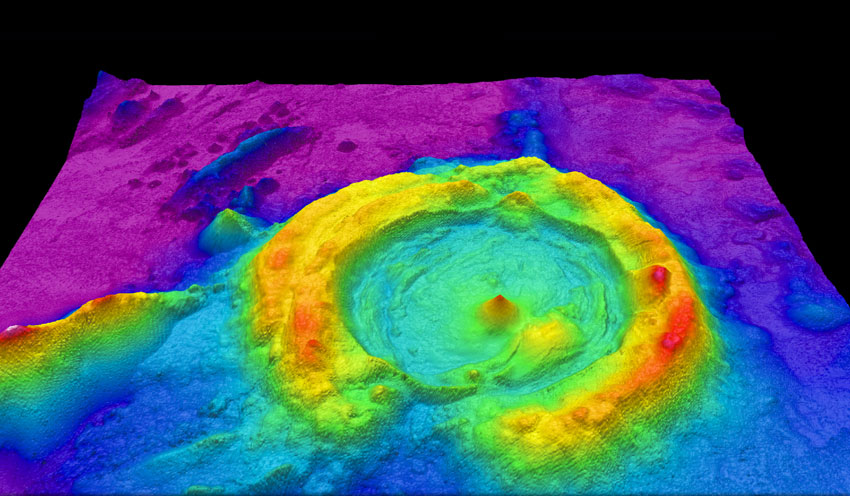
| LiDAR (Light Detection and Ranging) | Sends laser pulses to map terrain, even penetrating vegetation. | Forestry, construction, infrastructure. |
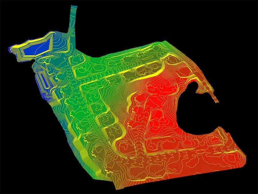
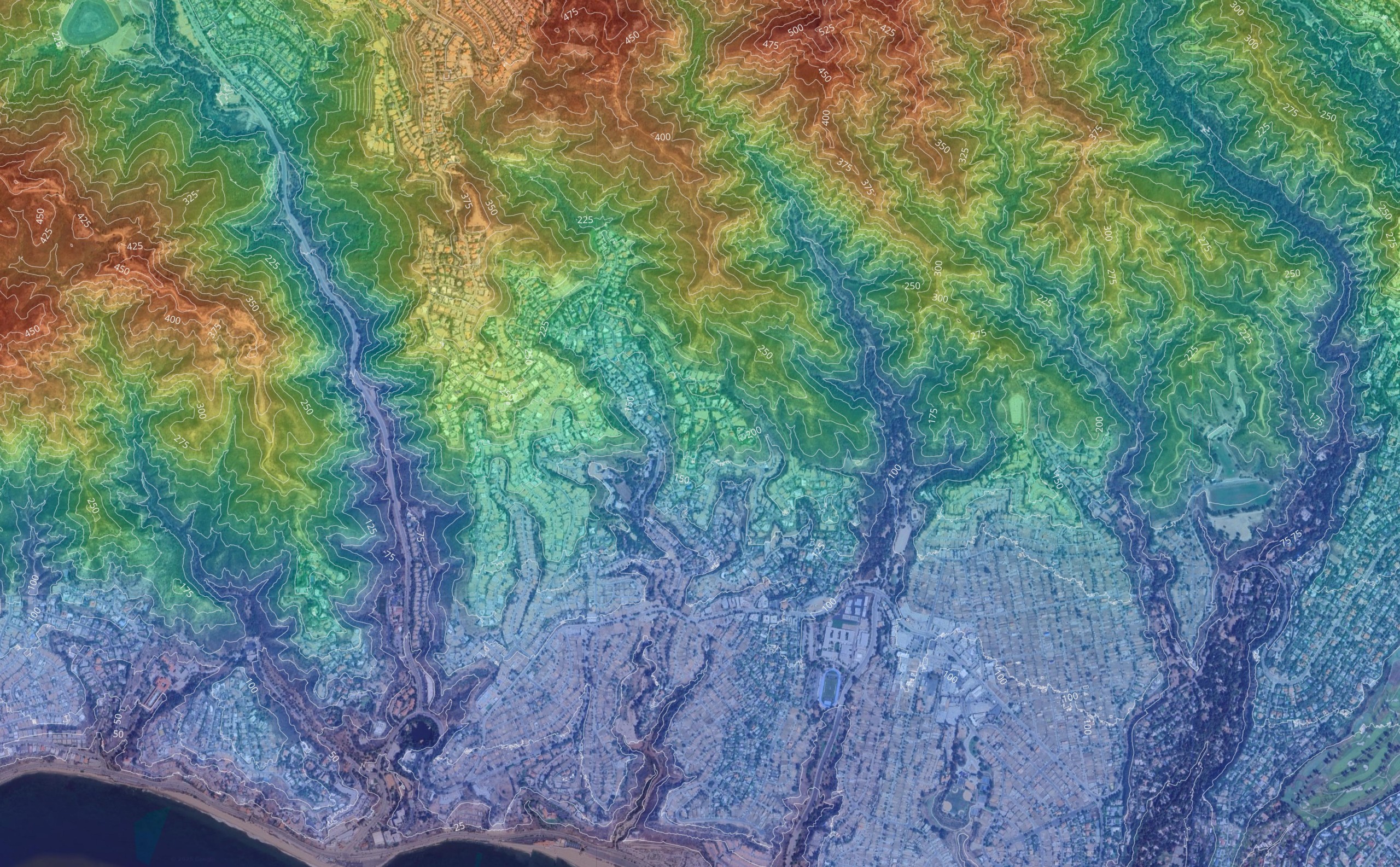
| Orthomosaic Mapping | Stitches thousands of georeferenced images into a single, accurate aerial map. | Land surveys, urban planning, site inspections. |
Drones for aerial mapping offer a more detailed and efficient alternative to traditional land surveying. Research from the U.S. Geological Survey (USGS) highlights how drone-based LiDAR scanning delivers sub-centimeter accuracy, making it a game-changer for terrain modeling and infrastructure planning.
Regulatory compliance is also a key factor in drone mapping. The Federal Aviation Administration (FAA) provides guidelines for commercial drone pilots, ensuring safe and legal operations in aerial surveying and mapping.

How Drone Mapping Works
Drone mapping has transformed land surveying, construction site planning, and environmental monitoring by providing high-resolution aerial data with unmatched efficiency. Traditional surveying methods require extensive ground teams and longer processing times, while a mapping drone can capture detailed site data in just a few hours.
But what is drone mapping exactly, and how does it work? The process involves three critical steps: flight planning, data capture, and data processing.
1. Flight Planning: Preparing for Precision Mapping
Every successful drone mapping mission starts with a well-structured flight plan. The accuracy of the final 2D maps and 3D models depends heavily on how the drone collects data during its flight.
- Choosing the Right Mapping Drone – Selecting the correct aerial mapping drone depends on the project’s scope. Fixed-wing drones are ideal for large land surveys, while quadcopters offer greater maneuverability for smaller, complex sites.
- Flight Altitude and Path Optimization – Higher altitudes cover larger areas quickly, while lower-altitude flights capture greater detail. Pilots program overlapping flight paths to ensure complete coverage.
According to DroneDeploy, optimizing drone flight paths can improve survey accuracy by up to 40%, reducing errors in data collection.
2. Data Capture: Collecting High-Resolution Imagery
The next step involves deploying a mapping drone to capture aerial images that will later be processed into a high-resolution map or 3D model.
- Using Drones for Mapping to Capture Data – Equipped with high-resolution cameras and RTK GPS, drones capture geotagged images across the designated site.
- Importance of Overlapping Images – To ensure accurate 3D reconstruction, pilots program drones to capture images with 60-80% overlap, allowing software to stitch them into a seamless map.
Research from Pix4D emphasizes that proper image overlap is crucial for generating accurate digital elevation models (DEMs) and georeferenced orthomosaic maps.
3. Data Processing: Turning Images into Usable Maps
Once the aerial mapping drone completes the flight, raw images are processed into highly detailed 2D maps or 3D models using specialized software.
- Stitching Images into 2D or 3D Models – Software aligns and processes thousands of overlapping images, correcting distortions and aligning geospatial data.
- Using Software for Precision Mapping – Industry leaders like Pix4D, DroneDeploy, and Agisoft Metashape specialize in generating accurate topographic surveys, volumetric calculations, and 3D reconstructions.
These software solutions use photogrammetry to transform raw drone imagery into precise maps and models, which are then used for land development, infrastructure planning, and environmental monitoring.
Many construction and earthwork teams pair photogrammetry software with platforms like Propeller Aero to manage drone survey data at scale. These systems make it easier to compare current surfaces against design models, track cut-and-fill progress, and share measurement reports across project teams without bouncing between multiple tools.

Types of Aerial Mapping & Applications
Aerial mapping with drones has become a critical tool across multiple industries, offering high-accuracy data collection without the need for traditional ground surveying. Drones for mapping are now widely used for construction planning, land surveying, agriculture, and environmental monitoring, providing real-time insights and cost-effective solutions.
Construction Drone Mapping
In the construction industry, drone for aerial mapping solutions provide accurate site planning, progress tracking, and volumetric analysis. By capturing high-resolution orthomosaics and 3D models, drones allow developers to compare as-built vs. as-planned structures with precision.
- Monitoring Progress – Regular construction drone mapping flights help site managers track development phases, ensuring projects stay on schedule.
- Elevation Modeling & Volumetric Calculations – Drones provide detailed elevation data, helping engineers analyze terrain and optimize earthmoving operations.
According to Dodge Data & Analytics, drone technology has reduced rework costs in construction by up to 25%, demonstrating its impact on project efficiency.
Land Surveying & Property Mapping
Traditional land surveys can take days or weeks, but drones for mapping drastically reduce the time needed to gather accurate boundary and topographic data.
- Drone Land Surveys for Real Estate Development – Developers use aerial mapping drones to assess land feasibility, zoning compliance, and infrastructure planning.
- Boundary Verification & Topographic Analysis – High-accuracy drone mapping ensures legal boundary verification and provides topographic insights crucial for large-scale development.
The National Society of Professional Surveyors (NSPS) recognizes drone surveying as a viable alternative to traditional field surveying, particularly in large or difficult-to-access areas.
Agricultural Mapping
Precision agriculture has seen significant advancements with the use of mapping drones equipped with multispectral and thermal imaging cameras. Farmers and agronomists rely on aerial mapping drones for crop health monitoring, irrigation analysis, and yield optimization.
- Mapping for Crop Health Monitoring – Drones with multispectral sensors detect early signs of crop stress, nutrient deficiencies, and pest infestations before they become visible to the naked eye.
- Detecting Irrigation Issues – Thermal imaging helps identify dry zones, overwatering, and irrigation inefficiencies, improving water resource management.
A study by NASA Harvest found that drone-based agricultural mapping can increase yield efficiency by up to 20%, making it an essential tool for modern farming.
Environmental & Infrastructure Mapping
Drones play a vital role in environmental monitoring and disaster response, offering rapid data collection in areas difficult to access by foot or traditional survey methods. Drones provide a bird’s eye view, offering detailed perspectives that are crucial for environmental monitoring and disaster response.
- Coastal Erosion & Floodplain Analysis – Aerial mapping drones track changes in coastline formations, flood risks, and soil erosion over time.
- Disaster Response & Damage Assessment – After natural disasters, drones provide immediate aerial views, helping authorities and relief organizations assess affected areas and plan recovery efforts.
The United States Geological Survey (USGS) has integrated drone-based aerial mapping into disaster response planning, improving flood risk analysis and post-disaster recovery efforts.

Disaster Response and Recovery
Assessing Damage and Identifying Areas of Need
Aerial mapping plays a crucial role in disaster response and recovery efforts. By capturing high-resolution aerial imagery, emergency responders can quickly assess damage and identify areas of need. This information is essential for developing effective response strategies and allocating resources where they are most needed.
Aerial surveys can be conducted quickly and efficiently, providing critical information in the aftermath of a disaster. The use of drones and other airborne platforms enables responders to access areas that may be difficult or dangerous to reach on foot. By analyzing aerial images, responders can identify areas of damage, assess the extent of destruction, and prioritize response efforts.
For instance, after a natural disaster such as a hurricane or earthquake, aerial surveys can provide a comprehensive overview of the affected area. High-resolution images allow responders to pinpoint damaged infrastructure, blocked roads, and isolated communities. This bird’s eye view is invaluable for coordinating rescue operations and delivering aid to those in need.
Best Drones for Mapping & Surveying
Choosing the right aerial mapping drone is critical for achieving accurate survey results. Different projects require different drone types, whether it’s large-scale land development, urban planning, or precision agriculture. The two primary categories of mapping drones are fixed-wing and multirotor drones, each with distinct advantages.
Fixed-Wing vs. Multirotor Drones for Mapping
| Drone Type | Best For | Advantages | Limitations |
|---|---|---|---|
| Fixed-Wing Drones | Large-scale mapping, agriculture, topographic surveys. | Long flight times, efficient for covering large areas. | Requires more space for takeoff and landing. |
| Multirotor Drones | Small-scale, urban mapping, detailed site inspections. | Greater maneuverability, easy to deploy, VTOL (Vertical Take-Off and Landing). | Shorter flight time, limited range. |
Fixed-wing drones are ideal for surveying expansive landscapes, while multirotor drones excel in urban environments and detailed inspections. DroneDeploy highlights that fixed-wing drones can map 10x larger areas per flight compared to multirotors, making them superior for projects requiring vast coverage.
Top Mapping Drones in 2025
Technology in drone mapping continues to evolve, with more accurate sensors, longer battery life, and improved RTK (Real-Time Kinematic) positioning. Below are the top mapping drones leading the industry in 2025.
1. DJI Matrice 300 RTK with Zenmuse L2 – Best for LiDAR and Photogrammetry
The DJI Matrice 300 RTK, paired with the Zenmuse L2 LiDAR, is one of the most advanced mapping drones available. It offers:
- RTK GPS for centimeter-level accuracy
- High-resolution LiDAR scanning
- Extended 55-minute flight time
This drone is ideal for topographic mapping, infrastructure inspections, and precision land surveys. According to DJI Enterprise, the Matrice 300 RTK has become the go-to choice for geospatial professionals due to its unmatched accuracy.

2. DJI Matrice 4E RTK – Affordable and High-Accuracy Mapping Drone
For professionals looking for an affordable yet highly accurate mapping drone, the DJI Matrice 4E RTK is an excellent choice. It features:
- Integrated RTK for survey-grade accuracy
- High-resolution RGB sensor for photogrammetry
- Compact and foldable design for easy transport
The Matrice 4E RTK is a strong competitor in the drone mapping market, offering cost-effective aerial surveying without sacrificing precision.

3. WingtraOne Gen II – Fixed-Wing Drone for Large-Scale Aerial Mapping
The WingtraOne Gen II is one of the most powerful fixed-wing mapping drones, designed for large-scale aerial mapping projects. Features include:
- Dual-camera system for photogrammetry and LiDAR mapping
- 90-minute flight time, covering over 100 km² per mission
- VTOL (Vertical Take-Off and Landing) for easy deployment
The Wingtra website highlights that its fixed-wing drones are used in high-precision corridor mapping, mining surveys, and environmental monitoring.

Benefits of Using Drones for Aerial Mapping
Mapping with a drone has become a game-changer for industries that rely on high-accuracy geospatial data, such as construction, real estate, agriculture, and infrastructure development. Traditional land surveys have long been the standard, but drones now offer a faster, safer, and more cost-effective alternative.
Drones vs. Traditional Land Surveys: A Performance Comparison
| Feature | Drones for Mapping | Traditional Land Surveys |
|---|---|---|
| Time Efficiency | Hours instead of days. | Longer fieldwork required. |
| Cost-Effectiveness | Lower operational costs. | Higher labor costs. |
| Data Accuracy | Sub-centimeter accuracy with RTK. | Highly accurate but slower. |
| Safety & Accessibility | Covers hard-to-reach areas. | Limited by terrain. |
Drones equipped with RTK (Real-Time Kinematic) positioning and LiDAR sensors provide sub-centimeter accuracy, making them comparable to traditional surveying methods. Pix4D reports that drone surveys can reduce fieldwork time by up to 80%, leading to significant cost savings.
Key Advantages of Drone Mapping
1. Faster Data Collection
A drone survey can capture an entire construction site, agricultural field, or large land area in just a few hours, whereas traditional methods often take days or weeks. According to DroneDeploy, drones reduce survey time by over 60%, improving project efficiency.
2. Lower Costs
Traditional land surveying requires a crew of surveyors, expensive total stations, and extensive field time, leading to higher operational costs. In contrast, mapping with a drone reduces labor expenses and minimizes costly delays. McKinsey & Company highlights that drone-based mapping can cut surveying costs by up to 50%.
3. Increased Accuracy with Advanced Sensors
Modern aerial mapping drones are equipped with:
- RTK and PPK GPS systems for centimeter-level accuracy
- LiDAR and photogrammetry sensors for detailed elevation modeling
- High-resolution RGB cameras for creating orthomosaic maps
The National Society of Professional Surveyors (NSPS) recognizes that drone surveys can match or exceed traditional survey accuracy in many applications.
4. Safe and Accessible Surveying
Drones eliminate the need for surveyors to traverse dangerous terrain, busy highways, or inaccessible construction zones. They allow for surveying in hazardous areas such as:
- Steep cliffs and mountainous regions
- Flood-prone areas and disaster zones
- High-risk industrial sites
A study by USGS found that drones significantly improve worker safety in environmental and geological surveys.
The Future of Drone Surveying
As drone technology continues to evolve, what is drone mapping today will only become more precise, automated, and scalable in the future. The combination of AI-powered image analysis, cloud-based processing, and improved battery life will make drone surveys even more valuable for industries that depend on fast, accurate, and cost-effective geospatial data.

Choosing the Right Drone Mapping Service
Selecting the right drone mapping service is crucial for obtaining accurate, high-quality survey data that meets project requirements. Not all drone service providers offer the same level of expertise, equipment, or regulatory compliance, so businesses must evaluate key factors before hiring a professional.
Key Factors to Consider When Hiring a Drone Mapping Service
| Factor | Why It Matters |
|---|---|
| Experience in Aerial Mapping & Drone Land Surveying | A company with extensive experience ensures accurate data collection and processing for industries like construction, real estate, and agriculture. |
| Equipment Used | The best drones for mapping come with RTK GPS, LiDAR sensors, and high-resolution cameras, ensuring precision down to the centimeter level. |
| Regulatory Compliance | Always hire FAA Part 107 licensed pilots who follow airspace regulations and safety guidelines. Compliance prevents legal and operational risks. |
| Deliverables | Ask about orthomosaic maps, 3D models, point clouds, and topographic surveys—ensuring the final output matches your project’s needs. |
According to FAA regulations, all commercial drone pilots must hold a Part 107 certification, ensuring they operate legally and safely.
Why AeroViews is the Best Choice for Drone Property Surveys & Mapping
At AeroViews, we specialize in drone surveys that deliver high-accuracy geospatial data for industries including construction, real estate, and infrastructure development. Our commitment to precision, efficiency, and regulatory compliance makes us a trusted partner for businesses requiring professional drone property surveys.
What Sets AeroViews Apart?
Over 10 years of experience in aerial mapping, drone surveying, and geospatial analysis.
State-of-the-art drone technology, including RTK-enabled drones and LiDAR sensors for centimeter-level accuracy.
FAA Part 107-certified pilots, ensuring all operations meet airspace and legal compliance.
Comprehensive deliverables, including orthomosaic maps, 3D models, DEMs (Digital Elevation Models), and volumetric reports.
Drones and Mapping: Making Data-Driven Decisions
High-quality drone surveys empower businesses to make smarter, data-driven decisions. Whether you need precise boundary verification, topographic mapping, or construction progress tracking, AeroViews provides the expertise and technology to elevate your project’s success.
Best Practices and Safety Considerations
Ensuring Safe and Effective Aerial Mapping
Aerial mapping requires careful planning and execution to ensure safe and effective operations. Here are some best practices and safety considerations to keep in mind:
- Obtain necessary permits and approvals: Ensure that you have the necessary permits and approvals to conduct aerial mapping operations in your area. Compliance with local regulations is crucial for legal and safe operations.
- Conduct thorough risk assessments: Identify potential hazards and develop strategies to mitigate risks. This includes assessing the terrain, weather conditions, and any obstacles that may affect the flight.
- Use appropriate equipment: Select equipment that is suitable for your aerial mapping needs, including high-resolution cameras and airborne platforms. High resolution cameras ensure that the captured images are detailed and accurate.
- Ensure accurate geolocation: Use ground control points and other techniques to ensure accurate geolocation of aerial images. Ground control points enhance the precision of the aerial imagery, aligning it accurately with the earth’s surface.
- Monitor weather conditions: Avoid flying in adverse weather conditions, such as strong winds or low visibility. Weather can significantly impact the quality of the aerial images and the safety of the flight.
- Maintain safe distances: Keep a safe distance from people, animals, and structures to avoid accidents or damage. This is especially important in populated or sensitive areas.
- Follow regulations: Comply with relevant regulations, such as those related to drone operations and privacy. Adhering to these regulations ensures that your operations are legal and respectful of privacy concerns.
By following these best practices and safety considerations, you can ensure safe and effective aerial mapping operations that provide accurate and reliable data. This approach not only enhances the quality of the mapping results but also ensures the safety of both the operators and the public.
Future of Drone Mapping & Industry Trends
The drone mapping industry is evolving rapidly, integrating AI, automation, and cloud-based processing to enhance efficiency and accuracy. As demand grows across construction, real estate, agriculture, and infrastructure, new technologies are transforming how drone mapping is conducted.
1. AI-Powered Drone Mapping for Real-Time Data Analysis
Artificial intelligence is revolutionizing drone mapping, allowing for faster data processing, automated object detection, and predictive analytics. AI-driven software can:
- Analyze mapping data in real time, detecting anomalies and changes in terrain.
- Automate classification of land features, improving precision in topographic surveys.
- Enhance drone survey accuracy by optimizing flight patterns based on previous data sets.
According to Pix4D, AI-powered photogrammetry software can now automatically generate 3D models and orthomosaics within minutes, reducing manual post-processing time by over 50%.
2. Autonomous Drone Fleets for Continuous Land Monitoring
A single mapping drone can already capture high-resolution aerial data, but autonomous drone fleets are set to take aerial surveying to the next level. These drones will:
- Conduct continuous land monitoring, ideal for large-scale infrastructure projects and agriculture.
- Communicate with each other, optimizing flight paths and avoiding redundant data collection.
- Self-charge and deploy on-demand, making real-time mapping possible with minimal human intervention.
Companies like Skydio and DJI Enterprise are developing fully autonomous drone fleets, improving efficiency in construction site monitoring and disaster response mapping.
3. 5G & Cloud-Based Mapping Solutions
The integration of 5G connectivity and cloud computing is making mapping with a drone more accessible and scalable. Faster data transfer speeds mean:
- Survey data can be processed in real time, eliminating the need for manual data downloads.
- Cloud-based platforms enable collaboration, allowing multiple stakeholders to access drone maps instantly.
- Drones can send live geospatial data for applications like emergency response and environmental monitoring.
A NASA study found that 5G-powered drone networks could enable fully automated drone traffic management systems, paving the way for scalable commercial mapping solutions.
What is Drone Mapping’s Role in the Future?
As drone technology advances, drone mapping will continue to replace traditional surveying and mapping methods, offering greater accuracy, cost savings, and real-time insights. From AI-powered analytics to autonomous fleets, these innovations will shape the future of aerial surveying, making mapping with drones more precise and efficient than ever before.
FAQ’s
Why is aerial photography important for providing detailed maps and coastal change assessments?
Aerial photography is crucial for providing detailed maps and conducting coastal change assessments due to its ability to capture high-resolution aerial imagery and bird’s eye views. By documenting changes over time, aerial photographs help in tracking coastal erosion, sediment movement, and other dynamic environmental factors. This data is invaluable for managing coastal resources and planning mitigation strategies in response to natural changes or weather conditions.
How do ground control points enhance the accuracy of aerial images and aerial imagery?
Ground control points (GCPs) enhance the accuracy of aerial imagery by providing reference locations that align the aerial photographs with the earth’s surface. These points ensure that the vertical position and horizontal alignment of images are precise, allowing for the creation of highly accurate digital maps. GCPs are essential for ensuring that measurements derived from aerial imagery are reliable and useful across various industries, from urban planning to environmental monitoring.
What role does the sun angle play in capturing effective aerial perspective?
The sun angle plays a significant role in capturing effective aerial perspectives by influencing the shadows and lighting conditions present in aerial photographs. A lower sun angle can enhance the visibility of terrain features by casting longer shadows, which provide depth and dimension to the imagery. Understanding and utilizing the optimal sun angle is important for obtaining clear and informative photographs that accurately represent the landscape.
How are near-infrared techniques used in aerial surveys to provide information?
Near-infrared techniques are used in aerial surveys to provide valuable information on vegetation health, water presence, and soil conditions. By capturing wavelengths beyond the visible light spectrum, near-infrared photographs reveal details that typical visual perspective might miss. These techniques are instrumental in agricultural monitoring, environmental assessments, and land management, as they help determine the health and status of different natural resources effectively.