Table Of Contents
Step 1: High-Accuracy Drone & LiDAR Data Capture
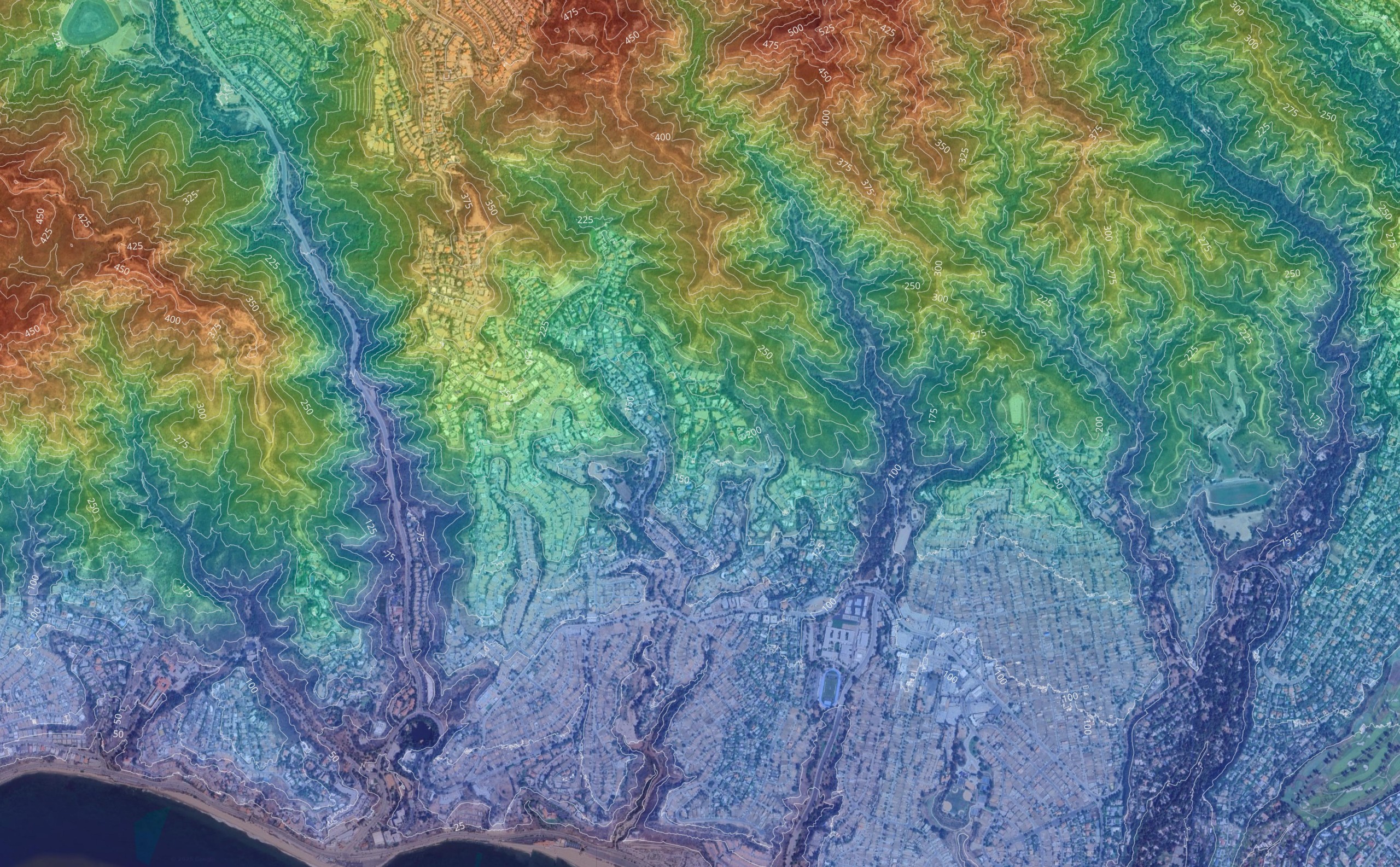
Before you can build a Trimble machine control model, you need accurate ground data. This is the foundation of the entire workflow. If the capture is wrong, the finished surface will also be wrong. As a result, the machine may follow an incorrect grade.
Today, advancements in RTK and GPS technology allow for centimeter-level accuracy. This level of precision is critical for GPS machine control systems. When site data is accurate, operators can trust the 3D view inside the cab. In addition, project managers can reduce rework and control costs more effectively.
Drone LiDAR plays a key role in modern 3D model machine control workflows. Instead of collecting a limited number of survey points, LiDAR captures millions of elevation points across the jobsite. When combined with well-placed survey control points and drone GCPs, the surface model reflects real-world terrain conditions, not estimates.
RTK and GPS Positioning for Consistent Elevations
RTK-enabled drones leverage base stations or correction networks to maintain highly accurate positioning across the jobsite. This ensures elevation data remains consistent across the entire site. As a result, the machine control model aligns closely with real field conditions.
Machine control systems often rely on on-site base stations to contrast signal data and stabilize positioning. This supports GPS machine control equipment operating in tandem with prepared 3D model machine control plans. When signals are stable and surfaces are clean, heavy equipment can execute grading tasks at exact coordinates with confidence.
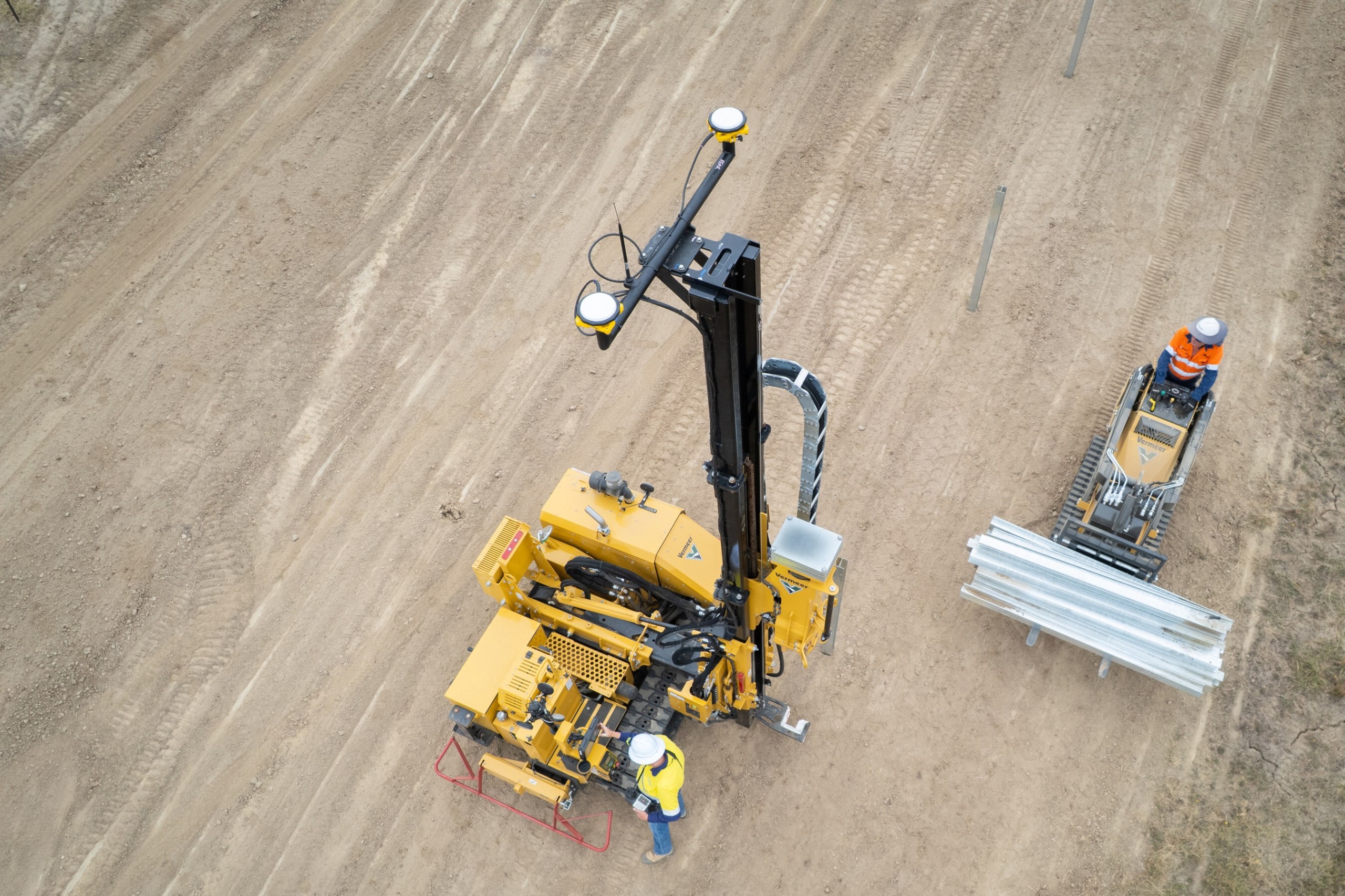
Machine control receivers mounted on bulldozers, graders, and excavators depend on reliable positioning data. These receivers communicate in real time with the control system to report location and blade position. However, even the best receiver cannot correct a poorly built surface. Therefore, accurate capture remains essential.
LiDAR Point Density and Surface Reliability
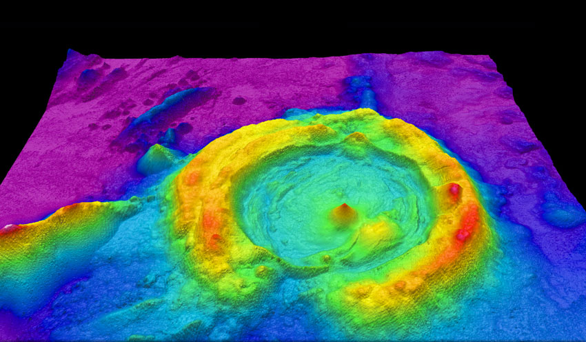
LiDAR technology captures dense point clouds that represent slopes, edges, and elevation changes in detail. Because of this density, terrain features are easier to define during surface modeling. In addition, high-resolution data improves breakline accuracy and overall TIN stability.
More complete capture also reduces the need for repeat site visits. Consequently, project timelines stay on track and field crews experience fewer delays. Contractors benefit from greater confidence before moving into grading operations.
Why Accurate Capture Drives Faster Grading
Field tests have shown that Trimble Earthworks can make grading operations up to 41% faster. In addition, automated blade height and tilt control can achieve finished grade 35–40% faster in certain conditions. However, those gains depend on the quality of the 3D machine control model guiding the equipment.
GPS machine control systems are designed to improve accuracy, productivity, safety, and quality on construction sites. When paired with accurate drone and LiDAR data, automated machine control reduces operator guesswork and supports consistent results. Therefore, precise data capture is not optional. It is what allows modern machine control systems to perform at their highest level.
Step 2: Point Cloud Cleanup and Digital Elevation Model Creation
Raw LiDAR data is powerful, but it is not immediately ready for machine control. In many workflows, it is complemented by drone photogrammetry for detailed mapping and modeling. Before a Trimble machine control model can guide heavy equipment, the point cloud must be cleaned, classified, and structured properly. Otherwise, even minor inconsistencies can translate into costly grading errors.
The first stage involves filtering noise and separating ground points from vegetation, debris, and vertical objects. This process ensures the Digital Elevation Model (DEM) reflects true earth conditions. As a result, the finished surface becomes reliable for automated machine control workflows.
Ground Classification and Surface Integrity
Ground classification is critical because automated machine control technology places responsibility for accuracy and speed in the hands of performance-enhancing systems. If the surface is flawed, machines will repeat that flaw consistently and at scale.
Advancements in GPS machine control have enabled equipment to execute grading tasks at exact coordinates. However, this level of precision depends on clean elevation data. Therefore, model builders must verify that only true ground points influence the surface.
When classification is performed correctly, contractors reduce manual stake placements and minimize field corrections. In addition, project teams gain confidence that the machine control model aligns with design intent.
Creating a Reliable Digital Elevation Model (DEM)
Once the point cloud is classified, a Digital Elevation Model is generated. This DEM represents the bare-earth surface and forms the base layer for the final TIN model inside Trimble Business Center.
At this stage, precision matters. Machine control receivers mounted on bulldozers, graders, and excavators rely on accurate vertical data, often within tight tolerances. A high degree of accuracy, typically within ±0.01 feet in receiver systems, means the digital surface must meet strict standards.
Furthermore, clean DEM creation improves cut-and-fill forecasting. As a result, contractors can better manage material quantities, reduce waste, and protect project budgets.
Preparing Data for Automated Machine Control
The construction industry is increasingly adopting automated machine control to improve productivity and address a shortage of skilled operators. Because of this shift, surface modeling must support both experienced operators and newer crew members.
Automated machine control allows less-skilled operators to perform at a professional level. However, this only works when the machine control model is stable, error-free, and easy to interpret. Therefore, proper DEM creation directly impacts field performance.
Clients often describe machine control solutions as a “second set of eyes” on the jobsite. When surfaces are built correctly from the start, equipment follows the model with consistency. Consequently, project timelines accelerate and unexpected grading corrections decrease.
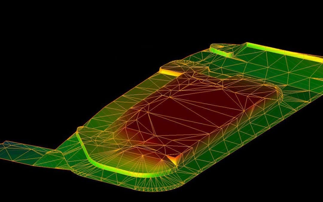
Step 3: Surface Modeling in Trimble Business Center
Once the Digital Elevation Model is complete, the data moves into Trimble Business Center for surface refinement and machine-ready preparation. This is where raw terrain becomes an actionable 3D machine control model.
Surface modeling requires more than simply connecting points. Engineers and experienced model builders develop structured TIN surfaces that guide dozers, motor graders, and excavators with precision. As a result, machine operators can rely on the model instead of constantly comparing elevations to paper plans.
From DEM to TIN: Building a Controlled Surface
A stable TIN surface ensures that grading equipment responds efficiently to automated steering and blade control inputs. Positioning sensors and machine control receivers interpret the model in real time. Therefore, any surface irregularity can affect performance across the entire range of the jobsite.
Modern automation has evolved significantly over the decades. Early systems relied on rotating lasers and basic elevation controls. Later, total stations expanded positioning accuracy. Today, GPS machine control integrates advanced connectivity and real-time data display inside the cab, supported by high-accuracy drone survey workflows using LiDAR, RTK, and photogrammetry.
Because of this evolution, surface development must meet higher requirements than ever before. The model must be clean, compatible with the machine control system, and structured for ease of use. Otherwise, operators may struggle with unexpected grade behavior.
Supporting Dozers, Motor Graders, and Excavators
Different machines respond to surface models in different ways. Dozers rely on automated blade adjustments. Motor graders depend on precise cross-slope control. Excavators require accurate bucket positioning to achieve final grade.
Automated machine control allows less-experienced operators to perform like seasoned professionals. However, the model must be developed carefully to support that automation. When done correctly, equipment moves efficiently, reduces fuel waste, and completes grading tasks quickly.
In addition, machine control reduces the need to constantly compare physical stakes with digital surfaces. This improves safety and helps construction professionals focus on workflow instead of constant manual verification.
Ensuring Compatibility and Field Readiness
Compatibility is a key factor when building a machine control model. The surface must integrate smoothly with the control display inside the machine. It must also support positioning sensors, receiver connectivity, and automated steering functions.
A user-friendly display enhances operator confidence. When machine operators can clearly see the 3D design and the machine’s position in real time, productivity increases. As a result, teams can improve efficiency while maintaining accuracy.
Machine control systems play an important role in increasing productivity across a variety of construction applications, including grading, excavation, and paving. When surfaces are built correctly, automation works as intended. Consequently, projects progress faster and with fewer interruptions.
The construction industry is turning toward automation not just for convenience, but out of necessity. A shortage of skilled labor has increased adoption across dozers and graders. While excavator adoption developed more slowly in the past, changing workforce requirements are accelerating that shift.
Surface modeling in Trimble Business Center ensures that automation performs as designed. When properly developed, the final 3D model machine control file provides a stable foundation for field execution.
Step 4: Deploying Machine Control Models Across the Construction Industry
Once the surface is finalized in Trimble Business Center, the model must be exported and deployed properly in the field. This step connects digital planning to real-world execution. Without careful deployment, even a well-built 3D model machine control file can underperform.
Across the construction industry, automation is becoming standard rather than optional. Contractors are moving away from traditional paper plans and manual staking methods. Instead, they rely on digital displays inside the cab to guide grading, excavation, and paving tasks in real time.
Moving Beyond Paper Plans to Digital Execution
For decades, crews relied heavily on paper plans, grade stakes, and constant rechecking. While that process worked, it required significant coordination and labor. In addition, minor interpretation differences could lead to costly rework.
Modern GPS machine control systems replace much of that manual process. The 3D surface is loaded directly into the machine control display, where operators see both the design and their real-time position. As a result, equipment follows the prepared model instead of repeatedly comparing measurements to paper plans.
This shift improves efficiency and reduces guesswork. It also helps protect budgets by minimizing overcutting, undercutting, and unnecessary material movement.
Field Deployment and Receiver Integration in the Construction Industry
Machine control receivers are mounted directly on heavy equipment such as dozers, motor graders, and excavators. These receivers communicate continuously with base stations and positioning sensors to maintain alignment with the 3D model machine control surface.
Signal range, durability, and battery life are critical factors during deployment. Equipment operates in harsh environments, so reliable connectivity is essential. When receivers maintain strong signal contrast from on-site base stations, the machine can operate in tandem with the digital model accurately and efficiently.
Furthermore, automated machine control technology allows new operators to perform with greater confidence. At the same time, experienced operators can work faster and with more precision. Therefore, well-deployed machine control models play an important role in improving safety, productivity, and overall project quality across the construction industry.
Perfect. We’ll close this with a strong authority-driven conclusion and naturally integrate every remaining fact without sounding forced.
We’ll keep readability high, sentence length controlled, and transitions smooth.
Here’s the final section.
The Evolution and Future of Machine Control in the Construction Industry
Machine control did not appear overnight. Early systems leveraged advancements in laser technology to improve water management in farming. Over time, sonic sensors expanded machine control to motor graders and pavers for elevation and steering. Later, robotic total stations and GPS advances laid the foundation for true 3D machine control.
Today, Trimble machine control systems represent the result of decades of progress. Precision guidance solutions first helped farmers improve crop yields, drive efficiencies, and reduce environmental impact. Those same principles now support grading, excavation, and paving across modern construction projects.
However, despite its significant benefits, machine control automation is not being adopted across all machines at the same rate. For example, excavators were slower to adopt automation when skilled operators were widely available. Now, the construction industry faces a shortage of experienced labor. As a result, companies must reassess equipment requirements and integrate automation more strategically.
Budget Protection, Productivity, and Reduced Rework
Trimble machine control helps maximize project budgets by reducing errors, improving data collection, and minimizing operator guesswork. When equipment follows a clean 3D model machine control surface, enhanced precision from GPS machine control reduces the need for manual stake placements. Consequently, teams save time, labor, and material resources.
Users consistently report that machine control solutions speed up project timelines and allow for quicker turnarounds. In addition, customers appreciate the consistency and reliability of machine control services, especially during preconstruction planning. When models are accurate from the beginning, field execution becomes smoother and more predictable.
Field Hardware, Connectivity, and Real-World Performance
Machine control receivers must perform reliably in demanding environments. The range of the machine control receiver is especially important on larger job sites, where signal stability can affect grading performance. Likewise, good battery life is essential to ensure the system lasts throughout the workday without interruption.
Modern machine control systems also rely on user-friendly interfaces. Clear displays allow operators to adapt quickly, whether they are experienced professionals or newer machine operators. When the interface is intuitive, productivity increases and training time decreases.
At the same time, machine control models built by knowledgeable model builders tend to be error-free and easy to interpret. This directly enhances field operations. Clients frequently express satisfaction with responsive teams who understand both the modeling process and real-world grading requirements.
Why Model Quality Still Matters Most
While hardware, automation, and connectivity continue to improve, the underlying surface remains the most critical component. A stable, compatible, and well-structured 3D model machine control file allows automated systems to operate as intended.
As adoption continues to grow, the demand for high-quality surface modeling will only increase. Contractors are turning to digital workflows not just for convenience, but to improve efficiency, protect budgets, and address workforce challenges.
When drone surveying services using LiDAR and photogrammetry are executed correctly and drone and LiDAR data are transformed into Trimble-ready surfaces, the result is more than just a model. It becomes a performance tool that drives accuracy, productivity, and measurable project outcomes.
Ready to Build a Machine Control Model That Performs in the Field?
Machine control automation is only as strong as the surface guiding it. Whether you are working from engineered plans or need high-accuracy drone and LiDAR capture, the quality of your 3D model machine control file directly impacts grading speed, accuracy, and overall project performance.
At AeroViews, we specialize in transforming terrain data and civil plans into clean, compatible, field-ready models for Trimble and GPS machine control systems, supported by local drone services near you. Our workflow is designed to reduce rework, improve efficiency, and support confident equipment operation from day one.
If you have existing CAD files, we can review your plans and provide a fixed quote for machine control modeling. If you need site capture, our RTK-enabled drone mapping services and LiDAR workflows deliver the precision required for reliable surface development.
Upload your plans or request a site evaluation today. Let’s build a machine control model that helps your project move faster, operate efficiently, and stay on grade.