Table Of Contents
Geospatial services have become essential tools for understanding and managing our physical world. From tracking environmental changes to coordinating emergency response operations, these technologies provide the spatial intelligence needed to make informed decisions across virtually every industry.
But what are geospatial services, exactly? Geospatial services involve the collection, storage, processing, analysis, and presentation of geographic or spatial data. These services integrate technologies like Geographic Information Systems, remote sensing, and Global Positioning Systems to help organizations answer critical spatial questions: Where are things located? How are they changing? What patterns exist across different locations?
In simpler terms, geospatial services help us understand the world in smarter ways. Think about planning a new highway. Instead of sending survey crews to manually measure every mile of terrain, geospatial services use drones and satellites to capture accurate elevation data in hours rather than weeks. When a landslide blocks a road, emergency response teams can deploy aerial mapping to assess the damage within 48 hours, creating detailed 3D models that show exactly where the ground has shifted and which structures are at risk.
Geospatial data forms the foundation for strategic analysis in fields ranging from urban planning and infrastructure development to disaster response and environmental monitoring. Modern geospatial technologies can achieve sub-centimeter accuracy, enabling precise measurements for construction projects, accurate mapping of natural disasters, and real-time tracking of assets across vast geographic areas.
This guide explores the core components of geospatial services, the technologies that power them, and the practical applications transforming how businesses, governments, and organizations operate. Whether you’re managing infrastructure projects, responding to emergencies, or analyzing environmental conditions, understanding geospatial services is essential for leveraging spatial data effectively.
Geospatial Services Meaning
Geospatial services encompass professional solutions that leverage location-based data, spatial technologies, and analytical methods to interpret, organize, and display information about Earth’s terrain and geographic characteristics. These services help answer essential spatial questions that drive decision-making across industries.
At their foundation, geospatial services integrate various technologies and methodologies to collect, analyze, and visualize information tied to specific locations on Earth. The term “geospatial” combines geography with spatial relationships, meaning these services focus on where things are located and how they relate to each other across physical space.
Geospatial services empower better decisions across land, infrastructure, and environmental assets. Organizations use these services to coordinate deliveries, manage infrastructure, plan conservation efforts, and respond to emergencies. From a construction company calculating earthwork volumes on a development site to environmental agencies tracking deforestation patterns, geospatial services transform raw location data into actionable intelligence.
The power of geospatial services lies in their ability to reveal patterns and relationships that remain hidden in traditional data formats. When emergency responders arrive at a landslide scene, geospatial mapping services can overlay current terrain conditions with historical data, infrastructure locations, and population density to prioritize rescue efforts and assess risks. This spatial perspective changes how organizations understand challenges and identify solutions.
Geographic Information Systems
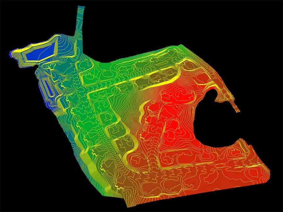
Geographic Information Systems are computer-based systems that capture, store, analyze, and display geographically referenced data. GIS technology serves as the backbone of modern geospatial services, enabling organizations to layer multiple data types and extract meaningful insights from spatial relationships.
Geographic Information
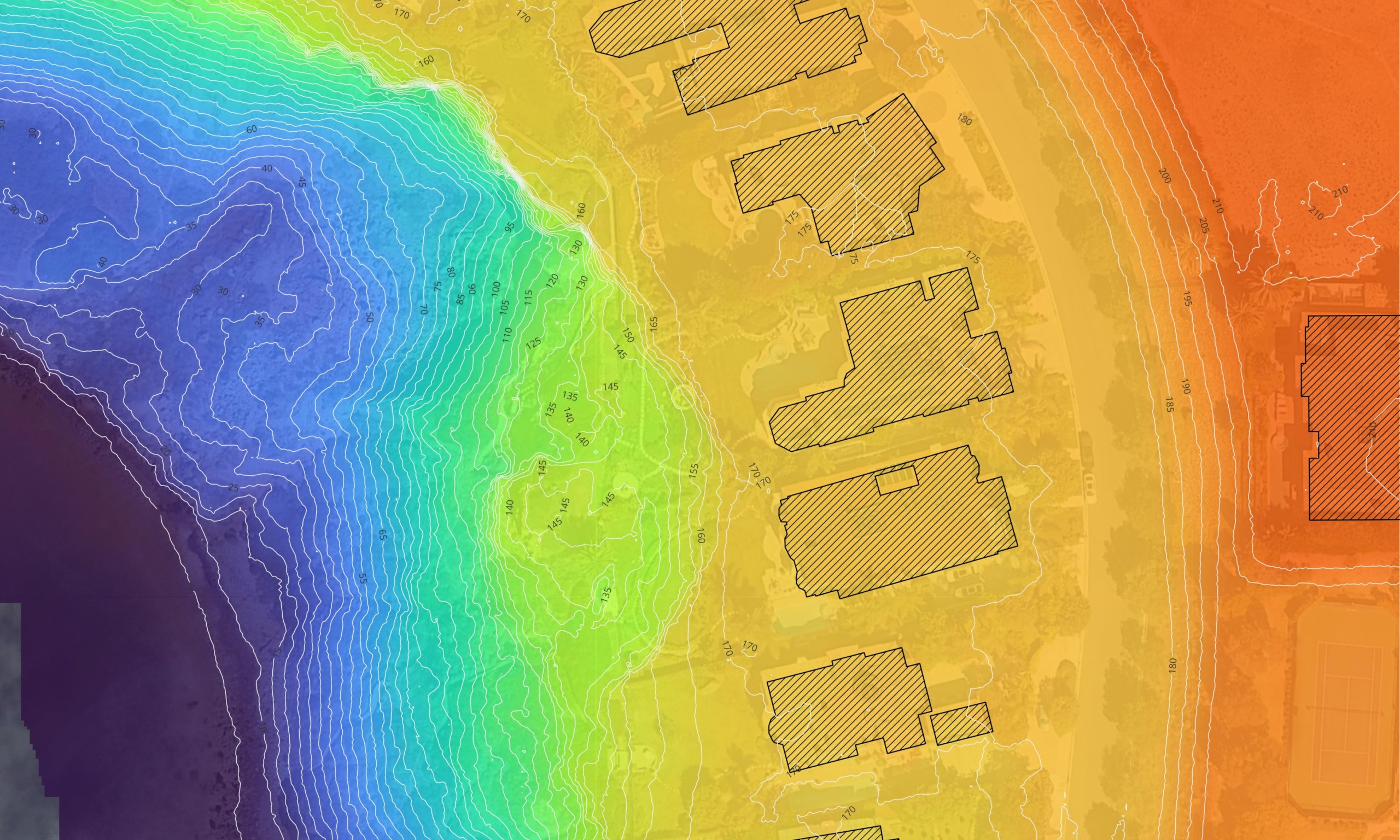
GIS platforms layer grid datasets, vector geometry, and live feeds to detect spatial relationships and geographic trends within defined areas. Grid-based datasets capture surface characteristics through pixel arrays, with each cell storing measurements for particular variables such as height or heat levels. Coordinate-based geometry captures location features as points, line segments, and closed shapes, making it particularly effective for depicting streets, property lines, and infrastructure assets.
| Data Type | Structure | Best Use Cases | Examples |
|---|---|---|---|
| Raster Data | Grid of pixels with values | Elevation mapping, temperature analysis, satellite imagery | Terrain models, weather data, aerial photography |
| Vector Data | Points, lines, polygons | Infrastructure mapping, property boundaries, road networks | Building footprints, utility lines, parcel maps |
Spatial Analysis
The power of GIS lies in its ability to answer complex spatial questions through detailed analysis. A city planner can layer population density data over transportation networks to identify where new transit routes would serve the most residents. Construction managers overlay soil conditions with topographic data to determine optimal building locations and foundation requirements.
Modern GIS platforms support advanced capabilities that go beyond simple map creation. Predictive GIS workflows leverage artificial intelligence to forecast risks like flood extents before they occur. Organizations can analyze historical patterns, current conditions, and predictive models within a single system to support data-driven decisions and improve operational efficiency.
Remote Sensing
Remote sensing captures surface data from a distance through specialized sensors mounted on orbital platforms, manned aircraft, or unmanned aerial systems. This technology captures data about the Earth from a distance, enabling organizations to monitor large geographic areas quickly and cost-effectively.
Satellite Imagery
Remote sensing systems collect geospatial data through various sensor types that detect different wavelengths of electromagnetic radiation. Optical sensors capture visible light imagery similar to standard photography, while thermal sensors detect heat signatures useful for identifying temperature variations. Satellite imagery provides broad coverage for monitoring environmental changes and tracking land use patterns over time.
Environmental agencies use satellite imagery to track deforestation patterns and assess water quality across vast regions. The ability to capture data from space enables consistent monitoring of areas that would be difficult or impossible to survey from the ground. This perspective reveals patterns and trends that inform conservation strategies and environmental management decisions.
Aerial Photography
Construction companies and infrastructure managers rely on aerial photography captured by drones for detailed site monitoring. Drones equipped with high-resolution cameras fly at lower altitudes than satellites, capturing imagery with ground sample distances measured in centimeters. This level of detail supports precise measurements for earthwork calculations, progress tracking, and quality control inspections.
Modern aerial photography delivers data at unprecedented speeds. When disaster response teams need to assess damage after natural disasters, drone-based remote sensing can map affected areas within hours. Emergency response operations benefit from rapid data collection that would take weeks using traditional ground-based surveying methods, proving critical when coordinating rescue efforts during time-sensitive situations.
Geospatial Data
Geospatial data is the foundation for strategic analysis and decision-making across industries. This data includes any information tied to a specific location on Earth, from GPS coordinates and elevation measurements to demographic statistics and infrastructure inventories. The quality and accuracy of geospatial data directly impacts the insights organizations can extract from spatial analysis.
Data Sources
Geospatial data comes from multiple sources that feed into comprehensive mapping and analysis workflows. Satellite imagery provides broad coverage for monitoring environmental changes and land use patterns. Ground control points establish precise reference locations that improve the accuracy of aerial surveys. Location data from GPS and Global Navigation Satellite Systems provides sub-centimeter accuracy for locating, mapping, and monitoring assets across project sites.
Live spatial data streams track continuously changing conditions including vehicular flow patterns and atmospheric dynamics.This continuous stream of spatial information enables organizations to respond quickly to changing conditions and maintain current awareness of operational environments.
Data Integration
Data integration represents a critical component of effective geospatial services. Organizations rarely rely on a single data source. Instead, they combine satellite imagery with drone surveys, GPS measurements, and existing geographic databases to create complete pictures of their operating environments. A transportation agency might integrate traffic sensor data with road network maps and weather forecasts to optimize route planning and predict congestion patterns.
The shift toward cloud-native pipelines has transformed how organizations manage geospatial data. Cloud-native pipelines enable data delivery from files to feeds, allowing real-time collaboration on massive datasets. Teams can access updated spatial information from any location, accelerating decision making and ensuring all stakeholders work from the same current data.
Geospatial Applications
Spatial data solutions transform location intelligence into actionable insights that fuel strategic decisions and operational improvements across diverse industries. These applications transform raw geographic information into actionable intelligence that solves real-world challenges and improves operational outcomes.
Urban Planning
Urban planning and infrastructure development rely heavily on geospatial applications to identify suitable locations for new facilities and optimize land use. City planners analyze spatial data to determine where population growth requires additional schools, hospitals, or public transportation. Infrastructure projects use geospatial mapping services to assess terrain conditions, identify potential obstacles, and calculate material requirements before construction begins.
Land use analysis through GIS enables planners to evaluate how different zoning scenarios might affect community development. Geospatial technologies help visualize proposed changes within existing neighborhood contexts, considering factors like traffic flow, environmental impact, and proximity to existing services. This spatial perspective supports informed decisions that balance growth with quality of life considerations.
Environmental Monitoring
Environmental monitoring represents another critical application area where geospatial technologies deliver measurable impact. Conservation organizations track deforestation by comparing satellite imagery across multiple time periods, measuring habitat loss with precise accuracy. Water quality monitoring combines remote sensing data with ground-based sensors to identify pollution sources and track remediation progress.
Climate change monitoring benefits from geospatial services that reveal temperature patterns, sea level changes, and shifting weather systems over time. Scientists use spatial analysis to model how environmental conditions might evolve under different scenarios, supporting efforts to manage natural resources and protect vulnerable ecosystems. These capabilities help develop effective protection strategies based on comprehensive geographic data.
Agricultural Monitoring
Agricultural monitoring through geospatial services enables farmers to optimize crop yields and manage resources efficiently. Remote sensing reveals variations in soil moisture, nutrient levels, and plant health across fields. Farmers use this spatial information to apply water, fertilizer, and pesticides only where needed, reducing costs while minimizing environmental impact.
Precision agriculture relies on geospatial data to guide automated equipment that plants seeds, applies treatments, and harvests crops with centimeter-level accuracy. GPS-guided tractors follow optimal paths that prevent overlap and reduce fuel consumption. This technology transforms farming from uniform field management to targeted interventions based on the specific needs of each crop zone.
Emergency Response
Geospatial services assist emergency agencies with real-time mapping, incident coordination, and recovery planning during critical situations. When disasters strike, the ability to quickly assess damage, identify affected populations, and coordinate rescue efforts can save lives. Emergency response teams rely on geospatial technologies to make informed decisions under extreme time pressure.
Disaster Response
Disaster response operations benefit from rapid geospatial data collection that traditional methods cannot match. Within 48 hours of a landslide, earthquake, or flood event, drone-based mapping can deliver detailed assessments of affected areas. Automated damage assessment technology compares pre-event imagery with post-disaster surveys to identify structural damage, road blockages, and areas requiring immediate attention.
Natural disasters create chaotic environments where coordination across multiple agencies becomes essential. Geospatial services enable incident commanders to share spatial information across teams, ensuring fire departments, medical responders, and utility crews all work from the same accurate maps. This coordination reduces duplication of effort and helps agencies avoid sending resources to areas already covered by other teams.
Emergency Coordination
Digital twins provide emergency planners with detailed 3D replicas of physical assets used for simulating scenarios before disasters occur. Cities create digital representations of infrastructure networks to model how flooding might impact critical utilities or transportation systems. When actual emergencies happen, responders overlay real-time data onto these digital twins to visualize current conditions and predict how situations might evolve.
Complex challenges during emergencies require evaluating numerous variables simultaneously. Geospatial analysis helps emergency managers identify evacuation routes, locate temporary shelters, and position resources strategically. Spatial data reveals which hospitals have capacity, where supply distribution points should be established, and how to navigate around damaged infrastructure. This level of situational awareness enables faster, more effective responses that save lives and reduce property damage.
Key Geospatial Technologies
Geospatial technology integrates multiple systems into unified workflows that capture, process, and analyze spatial data. Modern geospatial services combine hardware, software, and analytical methods to deliver actionable intelligence across industries. Understanding these core technologies helps organizations select the right tools for their specific mapping and analysis needs.
Global Positioning System GPS
GPS operates as an orbital navigation network that delivers accurate location coordinates and time data to any point on the planet. GPS provides the foundational location data that anchors all geospatial applications. Global Navigation Satellite Systems extend beyond GPS to include international positioning networks that provide sub-centimeter accuracy for surveying and mapping projects.
Construction sites use GPS to guide equipment operators and establish control points for earthwork calculations. Survey-grade GPS receivers capture coordinates with accuracy measured in centimeters, enabling precise measurements for property boundaries, infrastructure placement, and topographic surveys. This level of precision ensures that designs translate accurately from digital models to physical construction.
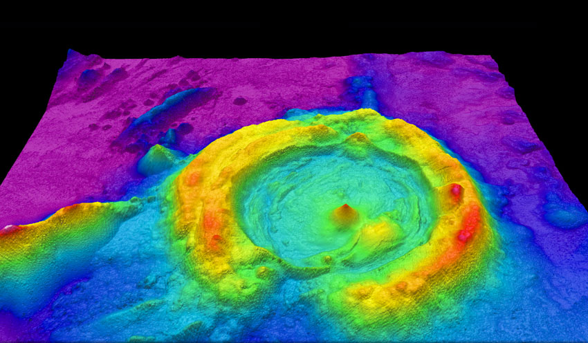
LiDAR Technology
LiDAR uses lasers to measure distances for detailed terrain mapping and three-dimensional modeling. Aircraft and drones equipped with LiDAR sensors emit laser pulses that bounce off surfaces below, recording elevation data at millions of points per second. This point cloud data creates highly accurate digital representations of terrain, vegetation, and built structures.
The accuracy of LiDAR makes it essential for projects requiring precise elevation measurements. Infrastructure planners use LiDAR to model flood risks, calculate drainage patterns, and design roads that follow optimal grades. Forestry managers measure tree heights and canopy density without ground surveys. Emergency responders assess landslide volumes and structural shifts after disasters, supporting risk assessment and recovery planning.
Photogrammetry
Photogrammetry is used to create accurate measurements and 3D models from photographs captured by drones or aircraft. Software analyzes overlapping images to calculate distances, areas, and volumes through triangulation methods. The result is detailed orthomosaic maps and digital elevation models that support construction monitoring, volumetric analysis, and site documentation.
Photogrammetry complements LiDAR by offering cost-effective solutions for projects that don’t require absolute precision. Construction companies use photogrammetric surveys to track progress, calculate stockpile volumes, and document site conditions. The visual clarity of photo-based models helps stakeholders understand project status without technical expertise in reading survey data.
| Technology | Accuracy Range | Best Applications | Data Collection Speed | Typical Cost |
|---|---|---|---|---|
| GPS/GNSS | 1–3 cm (RTK/PPK) | Ground control, asset tracking, equipment guidance | Real-time | Low |
| LiDAR | 2–5 cm vertical | Terrain mapping, vegetation analysis, infrastructure | Fast (airborne) | High |
| Photogrammetry | 3–10 cm (with GCPs) | Visual documentation, 3D modeling, volumetric analysis | Moderate | Medium |
| Satellite Imagery | 30 cm – 30 m | Large area monitoring, change detection, environmental tracking | Variable | Low–Medium |
Decision Making
Geospatial services enhance decision-making by providing valuable insights for informed choices across organizations. The ability to visualize spatial relationships and analyze geographic patterns transforms how leaders evaluate options and allocate resources.
Data-Driven Decisions
Data-driven decisions require access to accurate, timely information presented in formats that reveal meaningful patterns. Geospatial analysis converts raw location data into visual representations that highlight trends, anomalies, and opportunities. A utility company analyzing outage patterns can identify which grid sections experience frequent failures and prioritize infrastructure upgrades in areas affecting the most customers.
Business systems integrate geospatial capabilities to support strategic planning across departments. Retail chains analyze demographic data and competitor locations to identify optimal sites for new stores. Energy companies evaluate terrain, land use, and environmental conditions when planning transmission line routes. This spatial intelligence supports choices backed by comprehensive geographic analysis.
Better Decision Making
Better decision making emerges when teams can see exactly where problems exist and understand the geographic context surrounding each challenge. Organizations layer demographic information over service area maps to identify underserved populations. Resource allocation becomes more strategic when managers can visualize supply locations relative to demand centers, transportation networks, and operational constraints.
Informed Decision Making
Informed decision making benefits from the integration of multiple data sources within spatial frameworks. Complex challenges often require evaluating numerous variables simultaneously. Geospatial services enable decision makers to model different scenarios and compare outcomes before committing resources. Land use planners can simulate how proposed zoning changes might affect traffic patterns, property values, and environmental conditions. This capability to test options virtually reduces risk and builds confidence in final decisions.
Benefits of Geospatial Services
Geospatial services provide organizations with measurable advantages that extend beyond simple mapping capabilities. From reducing operational costs to improving safety outcomes, these technologies deliver value across multiple dimensions of business performance.
Cost Savings
Geospatial technologies can lead to cost savings by automating data collection and reducing mapping and surveying costs. Traditional land surveys require crews to physically visit sites, set up equipment, and manually record measurements over days or weeks. Drone-based aerial photography and LiDAR mapping complete the same work in hours, eliminating labor costs and equipment rental fees.
Construction projects benefit significantly from geospatial mapping services that calculate earthwork volumes with precision. Accurate cut and fill calculations prevent over-ordering materials, reducing waste and storage costs. Project managers identify grading issues early in the planning phase, avoiding expensive corrections during construction. These efficiencies translate directly to bottom-line savings on infrastructure projects.
Improved Efficiency
Geospatial services improve efficiency by streamlining workflows and enabling better resource allocation. Organizations eliminate redundant site visits by accessing current aerial imagery and spatial data from centralized platforms. Teams coordinate efforts using shared maps that show asset locations, work zones, and real-time progress updates.
Route optimization through spatial analysis reduces fuel consumption and vehicle wear across transportation fleets. Delivery companies analyze traffic patterns, road conditions, and customer locations to plan efficient daily routes. Utility companies use geospatial data to schedule maintenance crews based on geographic proximity, minimizing travel time between service calls.
Better Decision Making
Enhanced decision-making emerges when organizations can visualize problems within their geographic context. Geospatial services provide insights that remain hidden in spreadsheets or text reports. Environmental monitoring reveals pollution patterns that guide remediation priorities. Infrastructure assessments identify aging assets requiring replacement before failures occur.
Business systems integrate geospatial capabilities to support strategic planning across departments. Retail chains analyze demographic data and competitor locations to identify optimal sites for new stores. Energy companies evaluate terrain, land use, and environmental conditions when planning transmission line routes. This spatial intelligence supports informed decisions backed by comprehensive geographic analysis.
Additional Industry Applications
Geospatial services are applied every day across a wide range of sectors beyond urban planning and emergency response. Organizations across transportation, natural resources, utilities, and asset-intensive industries rely on spatial data to optimize operations and manage complex challenges.
Transportation Management
Transportation management leverages geospatial applications for route optimization and asset tracking. Logistics companies use spatial analysis to plan efficient delivery routes that minimize fuel costs and reduce travel time. Fleet managers track vehicle locations in real time, enabling dynamic routing adjustments based on traffic conditions or urgent delivery requests.
Traffic conditions monitoring through geospatial data helps transportation agencies identify congestion patterns and plan infrastructure improvements. Cities analyze how vehicles move through road networks to optimize signal timing and identify where additional capacity is needed. This operational visibility leads to cost savings and improved productivity across transportation networks.
Natural Resource Management
Natural resource management depends on geospatial services to monitor resource availability, track usage patterns, and plan conservation efforts. Forestry agencies use remote sensing to assess timber volumes, identify disease outbreaks, and plan sustainable harvesting schedules. Water resource managers analyze watershed conditions, predict drought impacts, and allocate supplies across competing demands.
Environmental management combines spatial data with ecological models to protect sensitive habitats and manage natural resources responsibly. Conservation planners identify corridors that connect fragmented habitats, enabling wildlife movement and genetic diversity. Mining companies use geospatial analysis to minimize environmental impact while extracting resources efficiently.
Asset Management
Asset management across infrastructure-intensive industries relies on geospatial services to track physical assets and plan maintenance activities. Utility companies map underground pipes, power lines, and communication cables within GIS platforms that link spatial locations to asset condition data. This integration enables predictive maintenance that addresses problems before failures occur.
Asset tracking through GPS and geospatial platforms provides real-time visibility into equipment locations and utilization rates. Construction companies monitor heavy machinery across multiple job sites, optimizing deployment and reducing idle time. Transportation agencies track bridge conditions, pavement quality, and sign inventories, prioritizing capital investments based on need and available funding.
Utility and Energy Sectors
Utility companies integrate geospatial technologies throughout operations, from planning new infrastructure to responding to outages. Electric utilities map service territories, model load growth, and design distribution networks using spatial analysis. Gas pipeline operators monitor right-of-way conditions and identify potential threats through regular aerial surveys.
Geospatial Analytics and Solutions
Geospatial analytics services transform raw spatial data into actionable insights that drive business outcomes. Organizations invest in geospatial solutions to solve specific operational challenges, from optimizing supply chains to predicting infrastructure failures. Understanding the range of available geospatial capabilities helps organizations select services that match their strategic objectives.
Geospatial Analysis Tools
Geospatial analysis extracts meaning from location data to reveal trends, detect anomalies, and support strategic decisions. Advanced analytics platforms process massive datasets to identify spatial patterns that remain invisible in traditional business intelligence tools. Spatial analysis techniques include proximity analysis to find features within specified distances, overlay analysis to combine multiple data layers, and network analysis to model flows through connected systems.
Problem solving through geospatial analysis addresses complex challenges across industries. Retailers identify trade areas and predict sales potential for new store locations. Healthcare organizations analyze disease clusters and plan service delivery to underserved populations. These analytical capabilities convert geographic questions into quantifiable answers that guide investments and operational strategies.
Geospatial Solutions
Geospatial solutions encompass the integrated services, technologies, and workflows that organizations deploy to meet specific needs. A complete solution might combine aerial photography, GPS surveying, data processing, and custom GIS applications tailored to particular industry requirements. Geospatial service providers design solutions that address unique challenges rather than offering one-size-fits-all products.
Geospatial capabilities vary significantly across service providers based on their technical expertise, equipment, and analytical methods. Some geospatial services companies specialize in specific sectors like construction or environmental monitoring, developing deep domain knowledge that informs their service delivery. Organizations selecting geospatial service providers should evaluate technical capabilities, industry experience, and the ability to integrate spatial data with existing business systems.
Digital Maps and Visualization
Digital maps serve as the primary interface through which users interact with geospatial information. Modern mapping platforms support interactive visualization that allows users to zoom, pan, and query spatial features dynamically. These digital maps layer diverse data types, from satellite imagery and property boundaries to real-time sensor feeds and demographic statistics.
Geospatial information services deliver maps and spatial data through web-based platforms accessible from any device. Cloud deployment eliminates the need for specialized software installations while ensuring all users access current data. Organizations customize map interfaces to highlight information relevant to their operations, creating focused views that support daily operations and strategic planning.
Geospatial Service Providers and Companies
Selecting the right geospatial services company requires understanding what different providers offer and how their capabilities align with project requirements. The geospatial industry includes specialists focused on specific technologies, generalists offering comprehensive solutions, and niche providers serving particular sectors.
What Geospatial Services Companies Deliver
Geospatial services companies provide end-to-end solutions from data collection through analysis and deliverable production. Full-service providers handle aerial photography missions, process raw sensor data into usable formats, and create custom maps or analytical reports. Some companies focus exclusively on data collection using drones or aircraft, while others specialize in data processing and GIS application development.
The scope of services varies based on company expertise and equipment capabilities. Advanced geospatial service providers operate fleets of survey-grade drones equipped with LiDAR sensors, high-resolution cameras, and RTK GPS systems. These companies maintain processing infrastructure and employ specialists who understand both geospatial technologies and the industries they serve. Data collection capabilities, processing turnaround times, and accuracy specifications differ significantly across providers.
Choosing Geospatial Service Providers
Organizations evaluating geospatial service providers should assess technical capabilities, industry experience, and operational capacity. Key components to evaluate include sensor technology quality, positioning accuracy methods, data processing workflows, and deliverable formats. Providers using RTK or PPK GPS corrections deliver higher accuracy than those relying on standard GPS, making them suitable for projects requiring survey-grade precision.
Emergency response capabilities matter for time-sensitive applications. Some geospatial services companies maintain rapid response protocols that mobilize equipment and personnel within 48 hours of disasters or urgent project needs. This responsiveness proves critical when assessing damage after natural disasters or addressing construction issues that halt work until surveys are completed.
| Evaluation Criteria | Why It Matters | Questions to Ask |
|---|---|---|
| Positioning Accuracy | Determines survey-grade reliability | Do you use RTK or PPK GPS corrections? |
| Response Time | Critical for emergency situations | What is your mobilization timeline? |
| Equipment Capabilities | Affects data quality and project suitability | What sensors and drones do you operate? |
| Industry Experience | Ensures domain-specific expertise | Have you completed similar projects in our sector? |
| Deliverable Formats | Must integrate with existing workflows | What file formats and GIS platforms do you support? |
| Data Security | Protects sensitive project information | How do you handle confidential location data? |
Industry Specialization
Geospatial services companies often specialize in particular sectors where they’ve developed deep expertise. Construction-focused providers understand earthwork calculations, progress monitoring, and volumetric analysis requirements. Environmental specialists bring knowledge of conservation planning, habitat assessment, and regulatory compliance documentation.
Infrastructure and utility companies benefit from working with geospatial service providers who understand asset management challenges and regulatory requirements specific to their sectors. Agricultural specialists offer expertise in crop monitoring, precision farming applications, and seasonal data collection timing. This industry focus enables providers to deliver solutions that address sector-specific challenges rather than generic mapping services.
Frequently Asked Questions
What is a geospatial service?
A geospatial service is any service that utilizes geographic or spatial data to collect, analyze, visualize, and interpret information about locations on Earth’s surface. These services integrate technologies like GIS, remote sensing, and GPS to transform raw location data into actionable insights. Geospatial services range from aerial mapping and surveying to spatial analysis and custom application development that helps organizations understand where things are, how they relate to each other, and how conditions change over time.
What is an example of geospatial?
An example of geospatial technology in action is using drones to survey a construction site and create a 3D terrain model. The drone captures aerial photography while recording precise GPS coordinates for every image. Processing software converts these images into an accurate digital elevation model showing existing topography. Construction managers then use this geospatial data to calculate cut and fill volumes, plan grading operations, and track progress throughout the project. This example demonstrates how geospatial services combine data collection, positioning technology, and spatial analysis to solve real-world challenges.
What are the functions of geospatial services?
The functions of geospatial services include data collection through remote sensing and surveying, data storage and management within GIS platforms, spatial analysis to identify patterns and relationships, and visualization through maps and 3D models. Additional functions include route optimization for transportation networks, asset tracking and management, environmental monitoring and change detection, emergency response planning and coordination, and predictive modeling to forecast future conditions. These functions support decision making across urban planning, infrastructure development, natural resource management, and disaster response operations.
What is meant by geospatial?
Geospatial refers to information or data that is tied to specific geographic locations on Earth’s surface. The term combines geography with spatial relationships, meaning it describes both where things are located and how they relate to each other across physical space. Geospatial information includes coordinates, addresses, boundaries, elevations, and any other data that can be mapped or analyzed based on location. This spatial perspective enables organizations to understand patterns, measure distances, calculate areas, and analyze how geographic factors influence operations, planning, and decision making.
What technologies power geospatial services?
Geospatial services rely on integrated technologies that work together to capture, process, and analyze spatial data. Geographic information systems GIS serve as the foundation, managing layers of geographic data and enabling spatial analysis. Geospatial web services deliver maps and spatial information through online platforms accessible from any device. These services use geographic coordinates to precisely locate features and enable location based data queries.